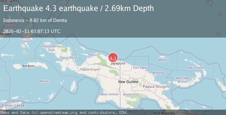
Earthquake near the north coast of Papua, Indonesia
Wed, 11 Feb 2026 03:07:13 GMT
Time1 week ago
Location
-2.1668, 140.0495
Depth
2.7 KM
Event Summary
A 4.3 magnitude earthquake struck on near the north coast of Papua, Indonesia, at Wed, 11 Feb 2026 03:07:13 GMT. Depth: 2.685546875km. Reviewed by VYT seismologists, this light quake occurred at a magnitude type of earthquake.
Magnitude
4.3
earthquake
Source
VYT
Intensity
-
Agency Reports
2 Sources| Source | Magnitude | Depth | Time |
|---|---|---|---|
| VYTPrimary | 4.3 | 3 km | 1 week ago |
| BMKG | 4.1 | 14 km | 1 week ago |
Earthquake Details
AutomaticEvent IDvyt_2mju675qk0nsc
Tsunami PotentialNo
Magnitude Typeearthquake
Nearest Places
- Tarfia15.8 km
- Tanjung Kamadara18.6 km
- Tanjung Korongwan20.3 km
- Teluk Matterer20.3 km
- Moaif20.4 km
Comments
Join the discussion about this event.
Latest Earthquakes
2.2Mag
OKLAHOMA
Time5 minutes ago
Depth3.40 km
SourceOK (Automatic)
1.6Mag
Southern Alaska
Time19 minutes ago
Depth48.58 km
SourceVYT (Automatic)
2.2Mag
PUERTO RICO
Time20 minutes ago
Depth13.80 km
SourcePR (Automatic)
2.3Mag
Antofagasta, Chile
Time21 minutes ago
Depth82.15 km
SourceVYT (Automatic)
2.1Mag
Southern Alaska
Time23 minutes ago
Depth64.21 km
SourceVYT (Automatic)
Nearby Earthquakes
2.5Mag
NEAR N COAST OF PAPUA, INDONESIA
Time1 month ago
Depth10.00 km
SourceBMKG (Automatic)
2.2Mag
Near North Coast of West Papua
Time3 weeks ago
Depth10.00 km
SourceBMKG (Automatic)
3.0Mag
NEAR N COAST OF PAPUA, INDONESIA
Time4 years ago
Depth10.00 km
SourceDJA (Automatic)
3.0Mag
NEAR N COAST OF PAPUA, INDONESIA
Time3 months ago
Depth10.00 km
SourceBMKG (Automatic)
2.1Mag
Near North Coast of West Papua
Time5 days ago
Depth10.00 km
SourceBMKG