Earthquake Southern California
Sun, 22 Feb 2026 00:56:42 GMT
Time1 hour ago
Location
33.1994, -115.5962
Depth
35.3 KM
Event Summary
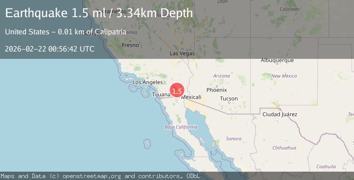
A 1.7 magnitude earthquake struck on Southern California, at Sun, 22 Feb 2026 00:56:42 GMT. Depth: 35.2783203125km. Reviewed by VYT seismologists, this minor quake occurred at a magnitude type of earthquake.
Magnitude
1.7
earthquake
Source
VYT
Intensity
-
Agency Reports
2 Sources| Source | Magnitude | Depth | Time |
|---|---|---|---|
| VYTPrimary | 1.7 | 35 km | 1 hour ago |
| USGS | 1.5 | 3 km | 1 hour ago |
Earthquake Details
AutomaticEvent IDvyt_2yx4l1dgwh0d5
Tsunami PotentialNo
Magnitude Typeearthquake
Nearest Places
- 1.2 km
- 1.4 km
- 1.4 km
- 1.5 km
- 1.7 km
Comments
Join the discussion about this event.
Latest Earthquakes
1.9Mag
Southern California
Time51 minutes ago
Depth16.97 km
SourceVYT (Automatic)
1.9Mag
Antofagasta, Chile
Time52 minutes ago
Depth0.00 km
SourceVYT (Automatic)
1.5Mag
Fox Islands, Aleutian Islands, Alaska
Time52 minutes ago
Depth0.24 km
SourceVYT (Automatic)
2.2Mag
ISLAND OF HAWAII, HAWAII
Time53 minutes ago
Depth0.70 km
SourceHV (Automatic)
3.8Mag
NORTH ISLAND OF NEW ZEALAND
Time56 minutes ago
Depth38.90 km
SourceGNS (Automatic)
Nearby Earthquakes
1.4Mag
9 km SW of Niland, CA
Time5 days ago
Depth2.96 km
SourceUSGS (Automatic)
3.0Mag
SOUTHERN CALIFORNIA
Time2 years ago
Depth3.00 km
SourceNEIR (Automatic)
3.0Mag
SOUTHERN CALIFORNIA
Time2 years ago
Depth10.00 km
SourceNEIC (Automatic)
3.0Mag
SOUTHERN CALIFORNIA
Time2 years ago
Depth10.00 km
SourceNEIC (Automatic)
4.0Mag
SOUTHERN CALIFORNIA
Time5 years ago
Depth10.00 km
SourceNEIC (Automatic)