Earthquake eastern New Guinea region, Papua New Guinea
Sat, 21 Feb 2026 06:18:45 GMT
Time1 hour ago
Location
-5.2729, 145.9467
Depth
91.7 KM
Event Summary
A 6.1 magnitude earthquake struck on eastern New Guinea region, Papua New Guinea, at Sat, 21 Feb 2026 06:18:45 GMT. Depth: 91.6748046875km. Reviewed by VYT seismologists, this strong quake occurred at a magnitude type of earthquake.
Magnitude
6.1
earthquake
Source
VYT
Intensity
-
Agency Reports
5 Sources| Source | Magnitude | Depth | Time |
|---|---|---|---|
| VYTPrimary | 5.8 | 92 km | 1 hour ago |
| BMKG | 6.1 | 33 km | 1 hour ago |
| EMSC | 5.9 | 78 km | 1 hour ago |
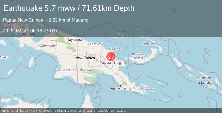
| NEIC | 5.7 | 72 km | 1 hour ago |
| USGS | 5.7 | 72 km | 1 hour ago |
Earthquake Details
AutomaticEvent IDvyt_34sopi7vd82l5
Tsunami PotentialNo
Magnitude Typeearthquake
Nearest Places
- 9.2 km
- 12.6 km
- 15.7 km
- 15.7 km
- 15.8 km
Comments
Join the discussion about this event.
Latest Earthquakes
2.7Mag
Bali Sea
Time1 hour ago
Depth17.45 km
SourceBMKG
2.2Mag
Southern California
Time1 hour ago
Depth3.91 km
SourceVYT (Automatic)
2.5Mag
18 km W of Delta, B.C., MX
Time1 hour ago
Depth10.16 km
SourceUSGS (Automatic)
1.8Mag
Antofagasta, Chile
Time1 hour ago
Depth0.00 km
SourceVYT (Automatic)
2.5Mag
Java, Indonesia
Time1 hour ago
Depth78.79 km
SourceBMKG
Nearby Earthquakes
5.9Mag
23 km ESE of Madang, Papua New Guinea
Time1 month ago
Depth89.96 km
SourceUSGS
5.2Mag
EASTERN NEW GUINEA REG., P.N.G.
Time6 years ago
Depth80.00 km
SourceEMSC (Automatic)
4.0Mag
EASTERN NEW GUINEA REG., P.N.G.
Time5 years ago
Depth94.00 km
SourceNEIC (Automatic)
5.8Mag
EASTERN NEW GUINEA REG., P.N.G.
Time16 years ago
Depth43.00 km
SourceEMSC (Automatic)
5.2Mag
EASTERN NEW GUINEA REG., P.N.G.
Time1 year ago
Depth78.00 km
SourceEMSC (Automatic)