Earthquake Alaska Peninsula
Fri, 13 Feb 2026 13:52:00 GMT
Time4 days ago
Location
57.8692, -156.8971
Depth
169.1 KM
Event Summary
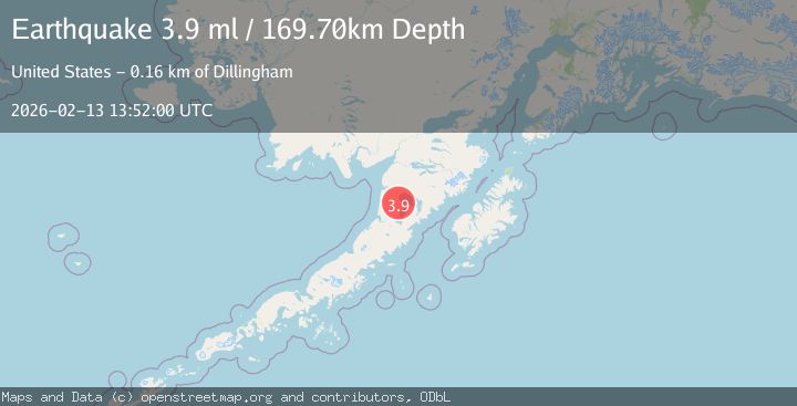
A 4.2 magnitude earthquake struck on Alaska Peninsula, at Fri, 13 Feb 2026 13:52:00 GMT. Depth: 169.0673828125km. Reviewed by VYT seismologists, this light quake occurred at a magnitude type of earthquake.
Magnitude
4.2
earthquake
Source
VYT
Intensity
-
Agency Reports
4 Sources| Source | Magnitude | Depth | Time |
|---|---|---|---|
| VYTPrimary | 4.2 | 169 km | 4 days ago |
| AK | 3.9 | 170 km | 4 days ago |
| USGS | 3.5 | 169 km | 4 days ago |
| NEIC | 3.5 | 167 km | 4 days ago |
Earthquake Details
AutomaticEvent IDvyt_35ifxh6m6k1vs
Tsunami PotentialNo
Magnitude Typeearthquake
Nearest Places
- Fort Jensen Airport11.9 km
- Blue Mountain Airport15.7 km
- Blue Mountain18.3 km
- Ukinrek Maars22.1 km
- The Gas Rocks23.4 km
Comments
Join the discussion about this event.
Latest Earthquakes
2.4Mag
Finland-Russia border region
Time2 minutes ago
Depth341.92 km
SourceVYT (Automatic)
0.9Mag
8 km W of Cobb, CA
Time7 minutes ago
Depth1.53 km
SourceUSGS (Automatic)
1.8Mag
Central Alaska
Time10 minutes ago
Depth2.08 km
SourceVYT (Automatic)
2.9Mag
WESTERN TURKEY
Time13 minutes ago
Depth11.80 km
SourceKOERI (Automatic)
2.8Mag
Sulawesi, Indonesia
Time13 minutes ago
Depth21.08 km
SourceBMKG
Nearby Earthquakes
3.0Mag
ALASKA PENINSULA
Time7 years ago
Depth155.00 km
SourceNEIR (Automatic)
4.0Mag
ALASKA PENINSULA
Time1 year ago
Depth8.00 km
SourceAK (Automatic)
3.0Mag
ALASKA PENINSULA
Time5 years ago
Depth145.00 km
SourceNEIC (Automatic)
3.0Mag
ALASKA PENINSULA
Time9 years ago
Depth5.00 km
SourceNEIR (Automatic)
3.0Mag
ALASKA PENINSULA
Time12 years ago
Depth34.00 km
SourceNEIR (Automatic)