Earthquake Banda Sea
Tue, 17 Feb 2026 10:57:15 GMT
Time1 day ago
Location
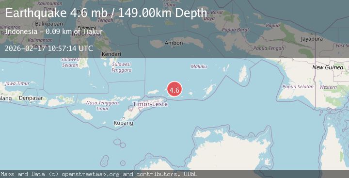
-7.6235, 128.2180
Depth
153.7 KM
Event Summary
A 4.7 magnitude earthquake struck on Banda Sea, at Tue, 17 Feb 2026 10:57:15 GMT. Depth: 153.6865234375km. Reviewed by VYT seismologists, this light quake occurred at a magnitude type of earthquake.
Magnitude
4.7
earthquake
Source
VYT
Intensity
-
Agency Reports
6 Sources| Source | Magnitude | Depth | Time |
|---|---|---|---|
| VYTPrimary | 4.7 | 154 km | 1 day ago |
| BMKG | 4.6 | 134 km | 1 day ago |
| GFZ | 4.7 | 149 km | 1 day ago |
| NEIC | 4.6 | 159 km | 1 day ago |
| USGS | 4.6 | 159 km | 1 day ago |
| EMSC | 4.6 | 149 km | 1 day ago |
Earthquake Details
AutomaticEvent IDvyt_35jstaidaq2da
Tsunami PotentialNo
Magnitude Typeearthquake
Nearest Places
- Kepulauan Barat Daya33.3 km
- Pulau Terbang Selatan47.0 km
- Pulau Musleur49.1 km
- Pulau Terbang Utara52.5 km
- Pantai Kiera58.4 km
Comments
Join the discussion about this event.
Latest Earthquakes
2.4Mag
Finland-Russia border region
Time1 minute ago
Depth341.92 km
SourceVYT (Automatic)
0.9Mag
8 km W of Cobb, CA
Time6 minutes ago
Depth1.53 km
SourceUSGS (Automatic)
1.8Mag
Central Alaska
Time9 minutes ago
Depth2.08 km
SourceVYT (Automatic)
2.9Mag
WESTERN TURKEY
Time12 minutes ago
Depth11.80 km
SourceKOERI (Automatic)
2.8Mag
Sulawesi, Indonesia
Time12 minutes ago
Depth21.08 km
SourceBMKG
Nearby Earthquakes
5.0Mag
KEPULAUAN BARAT DAYA, INDONESIA
Time11 years ago
Depth189.00 km
SourceEMSC (Automatic)
5.0Mag
KEPULAUAN BARAT DAYA, INDONESIA
Time10 years ago
Depth155.00 km
SourceEMSC (Automatic)
5.0Mag
KEPULAUAN BARAT DAYA, INDONESIA
Time8 years ago
Depth130.00 km
SourceEMSC (Automatic)
5.1Mag
KEPULAUAN BARAT DAYA, INDONESIA
Time6 years ago
Depth147.00 km
SourceEMSC (Automatic)
4.0Mag
KEPULAUAN BARAT DAYA, INDONESIA
Time10 months ago
Depth143.00 km
SourceBMKG (Automatic)