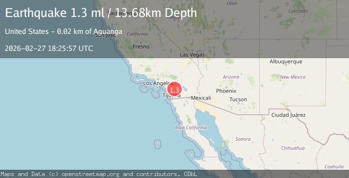
Earthquake Southern California
Fri, 27 Feb 2026 18:25:57 GMT
Time3 hours ago
Location
33.2838, -116.7383
Depth
18.9 KM
Event Summary
A 1.3 magnitude earthquake struck on Southern California, at Fri, 27 Feb 2026 18:25:57 GMT. Depth: 18.9208984375km. Reviewed by VYT seismologists, this minor quake occurred at a magnitude type of earthquake.
Magnitude
1.3
earthquake
Source
VYT
Intensity
-
Agency Reports
2 Sources| Source | Magnitude | Depth | Time |
|---|---|---|---|
| VYTPrimary | 1.2 | 19 km | 3 hours ago |
| USGS | 1.3 | 14 km | 3 hours ago |
Earthquake Details
AutomaticEvent IDvyt_36mxzjhe8wz0s
Tsunami PotentialNo
Magnitude Typeearthquake
Nearest Places
- 1.8 km
- 2.0 km
- 3.2 km
- 3.7 km
- 3.8 km
Comments
Join the discussion about this event.
Latest Earthquakes
0.9Mag
Southern Alaska
Time10 minutes ago
Depth23.32 km
SourceVYT (Automatic)
1.6Mag
WESTERN TURKEY
Time21 minutes ago
Depth12.90 km
SourceAFAD (Automatic)
3.4Mag
West Papua, Indonesia
Time27 minutes ago
Depth10.00 km
SourceBMKG
3.3Mag
SALTA, ARGENTINA
Time31 minutes ago
Depth202.00 km
SourceNSNA (Automatic)
3.7Mag
Salta, Argentina
Time31 minutes ago
Depth422.36 km
SourceVYT (Automatic)
Nearby Earthquakes
3.0Mag
SOUTHERN CALIFORNIA
Time7 years ago
Depth14.00 km
SourceNEIC (Automatic)
0.4Mag
3 km ESE of Lake Henshaw, CA
Time1 week ago
Depth11.15 km
SourceUSGS (Automatic)
2.0Mag
SOUTHERN CALIFORNIA
Time2 months ago
Depth10.30 km
SourceSCSN (Automatic)
1.2Mag
3 km ESE of Lake Henshaw, CA
Time0 months ago
Depth11.52 km
SourceUSGS (Automatic)
1.8Mag
3 km ESE of Lake Henshaw, CA
Time0 months ago
Depth11.72 km
SourceUSGS (Automatic)