Earthquake Alaska Peninsula
Fri, 13 Feb 2026 16:13:52 GMT
Time4 days ago
Location
58.2862, -154.9957
Depth
0.0 KM
Event Summary
A 1.6 magnitude earthquake struck on Alaska Peninsula, at Fri, 13 Feb 2026 16:13:52 GMT. Depth: 0km. Reviewed by VYT seismologists, this minor quake occurred at a magnitude type of earthquake.
Magnitude
1.6
earthquake
Source
VYT
Intensity
-
Agency Reports
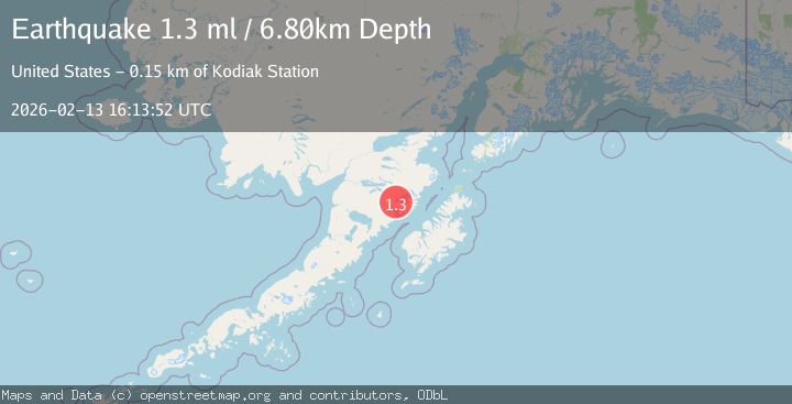
2 Sources| Source | Magnitude | Depth | Time |
|---|---|---|---|
| VYTPrimary | 1.6 | 0 km | 4 days ago |
| USGS | 1.3 | 7 km | 4 days ago |
Earthquake Details
AutomaticEvent IDvyt_3gjzj42gt1vhz
Tsunami PotentialNo
Magnitude Typeearthquake
Nearest Places
- The Knife Creek Glaciers0.7 km
- Mount Katmai2.7 km
- Crater Lake2.8 km
- The Knife Creek Glacier3.1 km
- Noisy Glacier8.0 km
Comments
Join the discussion about this event.
Latest Earthquakes
2.3Mag
Ceram Sea
Time14 hours ago
Depth10.00 km
SourceBMKG
2.5Mag
Greater Los Angeles area, California
Time14 hours ago
Depth135.74 km
SourceVYT (Automatic)
2.2Mag
Arizona
Time14 hours ago
Depth110.84 km
SourceVYT (Automatic)
2.0Mag
Poland
Time14 hours ago
Depth3.78 km
SourceVYT (Automatic)
2.5Mag
OFFSHORE GUATEMALA
Time14 hours ago
Depth66.00 km
SourceINET (Automatic)
Nearby Earthquakes
1.1Mag
86 km NNW of Karluk, Alaska
Time21 hours ago
Depth5.00 km
SourceUSGS (Automatic)
0.9Mag
85 km NNW of Karluk, Alaska
Time1 week ago
Depth5.00 km
SourceUSGS (Automatic)
1.9Mag
Alaska Peninsula
Time3 days ago
Depth0.00 km
SourceVYT (Automatic)
1.2Mag
85 km NNW of Karluk, Alaska
Time2 weeks ago
Depth5.00 km
SourceUSGS (Automatic)
0.9Mag
85 km NNW of Karluk, Alaska
Time3 weeks ago
Depth5.00 km
SourceUSGS (Automatic)