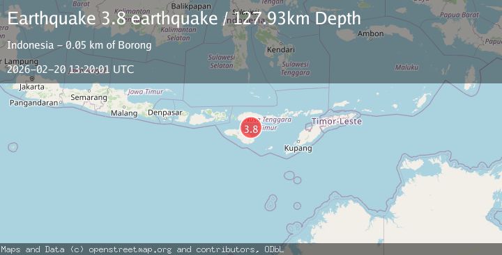
Earthquake Sumba region, Indonesia
Fri, 20 Feb 2026 13:20:01 GMT
Time1 hour ago
Location
-9.2708, 120.6477
Depth
127.9 KM
Event Summary
A 3.2 magnitude earthquake struck on Sumba region, Indonesia, at Fri, 20 Feb 2026 13:20:01 GMT. Depth: 127.9296875km. Reviewed by VYT seismologists, this minor quake occurred at a magnitude type of earthquake.
Magnitude
3.2
earthquake
Source
VYT
Intensity
-
Agency Reports
1 Sources| Source | Magnitude | Depth | Time |
|---|---|---|---|
| VYTPrimary | 3.2 | 128 km | 1 hour ago |
Earthquake Details
AutomaticEvent IDvyt_3jhwfxli8fb69
Tsunami PotentialNo
Magnitude Typeearthquake
Nearest Places
- Tanjung Batuata42.5 km
- Nangarawa44.5 km
- Tanjung Jarakeh44.5 km
- Tanjung Watuika44.6 km
- Nanga Rawa44.6 km
Comments
Join the discussion about this event.
Latest Earthquakes
2.7Mag
Western Australia
Time1 hour ago
Depth485.47 km
SourceVYT (Automatic)
2.7Mag
Minahasa, Sulawesi, Indonesia
Time1 hour ago
Depth201.29 km
SourceVYT (Automatic)
3.8Mag
Kenai Peninsula, Alaska
Time1 hour ago
Depth49.93 km
SourceVYT (Automatic)
5.7Mag
HINDU KUSH REGION, AFGHANISTAN
Time1 hour ago
Depth72.80 km
SourceGFZ (Automatic)
3.0Mag
WESTERN HONSHU, JAPAN
Time1 hour ago
Depth10.00 km
SourceJMA (Automatic)
Nearby Earthquakes
5.0Mag
SUMBA REGION, INDONESIA
Time13 years ago
Depth10.00 km
SourceEMSC (Automatic)
5.0Mag
SUMBA REGION, INDONESIA
Time1 year ago
Depth80.00 km
SourceEMSC (Automatic)
3.5Mag
SUMBA REGION, INDONESIA
Time1 month ago
Depth82.00 km
SourceBMKG (Automatic)
2.4Mag
Sumba Region, Indonesia
Time1 week ago
Depth57.80 km
SourceBMKG (Automatic)
3.0Mag
SUMBA REGION, INDONESIA
Time1 year ago
Depth42.00 km
SourceBMKG (Automatic)