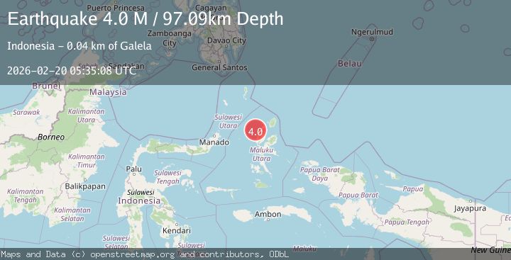
Earthquake Halmahera, Indonesia
Fri, 20 Feb 2026 05:35:09 GMT
Time1 hour ago
Location
1.8741, 127.4302
Depth
103.5 KM
Event Summary
A 3.7 magnitude earthquake struck on Halmahera, Indonesia, at Fri, 20 Feb 2026 05:35:09 GMT. Depth: 103.515625km. Reviewed by VYT seismologists, this minor quake occurred at a magnitude type of earthquake.
Magnitude
3.7
earthquake
Source
VYT
Intensity
-
Agency Reports
1 Sources| Source | Magnitude | Depth | Time |
|---|---|---|---|
| VYTPrimary | 3.7 | 104 km | 1 hour ago |
Earthquake Details
AutomaticEvent IDvyt_3n4obx338pmnl
Tsunami PotentialNo
Magnitude Typeearthquake
Nearest Places
- Pulau Tutu19.5 km
- Tanjung Tutumadehe19.9 km
- Tanjung Goauku20.6 km
- Tanjung Tobadiku-mhe20.6 km
- Pulau Moreporoco20.6 km
Comments
Join the discussion about this event.
Latest Earthquakes
1.6Mag
5 km S of Petrolia, CA
Time1 hour ago
Depth14.52 km
SourceUSGS (Automatic)
2.4Mag
Central Alaska
Time1 hour ago
Depth84.11 km
SourceVYT (Automatic)
2.3Mag
Dead Sea region
Time1 hour ago
Depth0.98 km
SourceVYT (Automatic)
2.4Mag
Northern Sumatra, Indonesia
Time1 hour ago
Depth5.00 km
SourceBMKG
2.7Mag
Andreanof Islands, Aleutian Islands, Alaska
Time1 hour ago
Depth3.05 km
SourceVYT (Automatic)
Nearby Earthquakes
5.0Mag
HALMAHERA, INDONESIA
Time5 years ago
Depth116.00 km
SourceEMSC (Automatic)
3.0Mag
HALMAHERA, INDONESIA
Time1 year ago
Depth105.00 km
SourceBMKG (Automatic)
3.0Mag
HALMAHERA, INDONESIA
Time1 month ago
Depth121.00 km
SourceBMKG (Automatic)
5.3Mag
HALMAHERA, INDONESIA
Time17 years ago
Depth100.00 km
SourceEMSC (Automatic)
3.4Mag
HALMAHERA, INDONESIA
Time1 month ago
Depth17.00 km
SourceBMKG (Automatic)