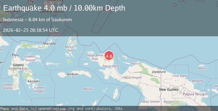
Earthquake near the north coast of Papua, Indonesia
Wed, 25 Feb 2026 20:38:57 GMT
Time1 hour ago
Location
-0.6318, 133.0167
Depth
2.4 KM
Event Summary
A 4.4 magnitude earthquake struck on near the north coast of Papua, Indonesia, at Wed, 25 Feb 2026 20:38:57 GMT. Depth: 2.44140625km. Reviewed by VYT seismologists, this light quake occurred at a magnitude type of earthquake.
Magnitude
4.4
earthquake
Source
VYT
Intensity
-
Agency Reports
2 Sources| Source | Magnitude | Depth | Time |
|---|---|---|---|
| VYTPrimary | 4.4 | 2 km | 1 hour ago |
| BMKG | 4.3 | 10 km | 1 hour ago |
Earthquake Details
AutomaticEvent IDvyt_9ppxnxuroh19
Tsunami PotentialNo
Magnitude Typeearthquake
Nearest Places
- 4.1 km
- 4.8 km
- 5.4 km
- 6.1 km
- 7.0 km
Comments
Join the discussion about this event.
Latest Earthquakes
2.6Mag
Fox Islands, Aleutian Islands, Alaska
Time1 hour ago
Depth0.00 km
SourceVYT (Automatic)
2.9Mag
Northern Territory, Australia
Time1 hour ago
Depth429.44 km
SourceVYT (Automatic)
2.5Mag
West Papua, Indonesia
Time1 hour ago
Depth30.73 km
SourceBMKG
2.0Mag
Kenai Peninsula, Alaska
Time1 hour ago
Depth144.90 km
SourceVYT (Automatic)
2.3Mag
Northern Sumatra, Indonesia
Time1 hour ago
Depth8.57 km
SourceBMKG
Nearby Earthquakes
2.6Mag
West Papua Region, Indonesia
Time0 months ago
Depth10.93 km
SourceBMKG (Automatic)
5.0Mag
NEAR N COAST OF PAPUA, INDONESIA
Time17 years ago
Depth60.00 km
SourceEMSC (Automatic)
5.3Mag
NEAR N COAST OF PAPUA, INDONESIA
Time17 years ago
Depth10.00 km
SourceEMSC (Automatic)
3.0Mag
NEAR N COAST OF PAPUA, INDONESIA
Time2 years ago
Depth10.00 km
SourceDJA (Automatic)
2.1Mag
West Papua Region, Indonesia
Time1 month ago
Depth10.00 km
SourceBMKG (Automatic)