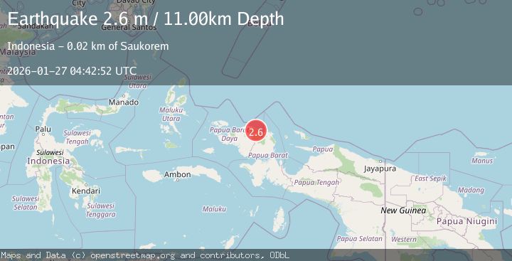
Earthquake West Papua Region, Indonesia
Tue, 27 Jan 2026 04:42:52 GMT
Time7 hours ago
Location
-0.6350, 133.0334
Depth
10.9 KM
Event Summary
A 2.6 magnitude earthquake struck on West Papua Region, Indonesia, at Tue, 27 Jan 2026 04:42:52 GMT. Depth: 10.934031km. Reviewed by BMKG seismologists, this minor quake occurred at a magnitude type of M.
Magnitude
2.6
M
Source
BMKG
Intensity
-
Agency Reports
1 Sources| Source | Magnitude | Depth | Time |
|---|---|---|---|
| BMKGPrimary | 2.6 | 11 km | 7 hours ago |
Earthquake Details
AutomaticEvent IDbmg2026bvwk
Tsunami PotentialNo
Magnitude TypeM
Nearest Places
- Kampung Manggapnut2.6 km
- Distrik Amberbaken3.6 km
- Kampung Sasui5.0 km
- Kampung Saukorem5.8 km
- Kampung Wasawmontem7.6 km
Comments
Join the discussion about this event.
Latest Earthquakes
2.5Mag
BAJA CALIFORNIA, MEXICO
Time7 hours ago
Depth20.50 km
SourceSCSN (Automatic)
2.9Mag
Sumba Region, Indonesia
Time7 hours ago
Depth4.58 km
SourceBMKG (Automatic)
1.6Mag
21 km WNW of Stanton, Texas
Time7 hours ago
Depth3.55 km
SourceUSGS (Automatic)
5.2Mag
EAST OF KURIL ISLANDS
Time7 hours ago
Depth13.00 km
SourceEMSC (Automatic)
3.4Mag
OFF E. COAST OF N. ISLAND, N.Z.
Time7 hours ago
Depth271.20 km
SourceGNS (Automatic)
Nearby Earthquakes
2.1Mag
West Papua Region, Indonesia
Time4 days ago
Depth10.00 km
SourceBMKG (Automatic)
2.1Mag
West Papua Region, Indonesia
Time3 days ago
Depth14.74 km
SourceBMKG (Automatic)
2.4Mag
West Papua Region, Indonesia
Time1 day ago
Depth10.00 km
SourceBMKG (Automatic)
2.1Mag
West Papua Region, Indonesia
Time5 days ago
Depth38.83 km
SourceBMKG (Automatic)
2.4Mag
West Papua Region, Indonesia
Time18 hours ago
Depth10.00 km
SourceBMKG (Automatic)