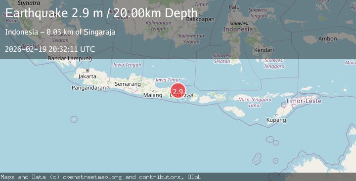
Earthquake Bali Sea
Thu, 19 Feb 2026 20:32:11 GMT
Time1 hour ago
Location
-7.9090, 114.8617
Depth
26.9 KM
Event Summary
A 2.6 magnitude earthquake struck on Bali Sea, at Thu, 19 Feb 2026 20:32:11 GMT. Depth: 26.85546875km. Reviewed by VYT seismologists, this minor quake occurred at a magnitude type of earthquake.
Magnitude
2.6
earthquake
Source
VYT
Intensity
-
Agency Reports
1 Sources| Source | Magnitude | Depth | Time |
|---|---|---|---|
| VYTPrimary | 2.6 | 27 km | 1 hour ago |
Earthquake Details
AutomaticEvent IDvyt_g8l3pzhr313y
Tsunami PotentialNo
Magnitude Typeearthquake
Nearest Places
- Rajatama29.0 km
- Temukus Road29.2 km
- Tanjung Gundul29.6 km
- Tanjung Ayer Poh30.6 km
- Pulau Celukan Bawang30.7 km
Comments
Join the discussion about this event.
Latest Earthquakes
2.3Mag
Southern Alaska
Time1 hour ago
Depth44.07 km
SourceVYT (Automatic)
2.4Mag
Andreanof Islands, Aleutian Islands, Alaska
Time1 hour ago
Depth14.77 km
SourceVYT (Automatic)
2.2Mag
Minahasa, Sulawesi, Indonesia
Time1 hour ago
Depth0.00 km
SourceVYT (Automatic)
1.3Mag
Southern Alaska
Time1 hour ago
Depth0.00 km
SourceVYT (Automatic)
1.2Mag
Central Alaska
Time1 hour ago
Depth32.71 km
SourceVYT (Automatic)
Nearby Earthquakes
3.0Mag
BALI REGION, INDONESIA
Time3 years ago
Depth13.00 km
SourceDJA (Automatic)
5.2Mag
BALI REGION, INDONESIA
Time6 years ago
Depth10.00 km
SourceEMSC (Automatic)
5.2Mag
BALI SEA
Time4 months ago
Depth10.00 km
SourceEMSC (Automatic)
2.5Mag
BALI REGION, INDONESIA
Time2 days ago
Depth10.00 km
SourceBMKG (Automatic)
3.0Mag
BALI REGION, INDONESIA
Time1 year ago
Depth13.00 km
SourceBMKG (Automatic)