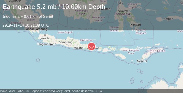
Earthquake BALI REGION, INDONESIA
Thu, 14 Nov 2019 10:21:39 GMT
Time6 years ago
Location
-8.1400, 114.8800
Depth
10.0 KM
Event Summary
A 5.2 magnitude earthquake struck on BALI REGION, INDONESIA, at Thu, 14 Nov 2019 10:21:39 GMT. Depth: 10km. Reviewed by EMSC seismologists, this moderate quake occurred at a magnitude type of mb.
Magnitude
5.2
mb
Source
EMSC
Intensity
-
Agency Reports
1 Sources| Source | Magnitude | Depth | Time |
|---|---|---|---|
| EMSCPrimary | 5.2 | 10 km | 6 years ago |
Earthquake Details
AutomaticEvent IDemsc_EMSC_20191114_0000051
Tsunami PotentialNo
Magnitude Typemb
Nearest Places
- Rajatama3.7 km
- Enjung Ponjokcukli5.6 km
- Tukad Banyuraras5.6 km
- Celuk Rajatamu5.6 km
- Tukad Anakan5.9 km
Comments
Join the discussion about this event.
Latest Earthquakes
1.1Mag
Kenai Peninsula, Alaska
Time23 hours ago
Depth53.22 km
SourceVYT (Automatic)
3.1Mag
Savu Sea
Time23 hours ago
Depth86.30 km
SourceVYT (Automatic)
2.6Mag
Java, Indonesia
Time23 hours ago
Depth144.90 km
SourceVYT (Automatic)
3.9Mag
Sunda Strait, Indonesia
Time23 hours ago
Depth97.11 km
SourceBMKG
1.1Mag
6 km N of Running Springs, CA
Time23 hours ago
Depth10.46 km
SourceUSGS (Automatic)
Nearby Earthquakes
3.0Mag
BALI REGION, INDONESIA
Time1 year ago
Depth13.00 km
SourceBMKG (Automatic)
3.0Mag
BALI REGION, INDONESIA
Time5 years ago
Depth10.00 km
SourceDJA (Automatic)
3.0Mag
BALI REGION, INDONESIA
Time3 years ago
Depth13.00 km
SourceDJA (Automatic)
3.0Mag
BALI REGION, INDONESIA
Time3 years ago
Depth237.00 km
SourceDJA (Automatic)
2.5Mag
Bali Region, Indonesia
Time1 week ago
Depth7.62 km
SourceBMKG (Automatic)