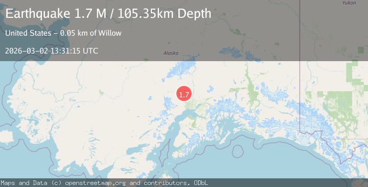
Earthquake Southern Alaska
Mon, 02 Mar 2026 13:31:15 GMT
Time4 hours ago
Location
61.9053, -150.9281
Depth
105.3 KM
Event Summary
A 1.7 magnitude earthquake struck on Southern Alaska, at Mon, 02 Mar 2026 13:31:15 GMT. Depth: 105.3466796875km. Reviewed by VYT seismologists, this minor quake occurred at a magnitude type of M.
Magnitude
1.7
M
Source
VYT
Intensity
-
Agency Reports
1 Sources| Source | Magnitude | Depth | Time |
|---|---|---|---|
| VYTPrimary | 1.7 | 105 km | 4 hours ago |
Earthquake Details
AutomaticEvent IDvyt_kfxozy8gs7h1
Tsunami PotentialNo
Magnitude TypeM
Nearest Places
- 0.8 km
- 1.0 km
- 1.4 km
- 2.8 km
- 2.8 km
Comments
Join the discussion about this event.
Latest Earthquakes
1.4Mag
Southern Alaska
Time4 hours ago
Depth87.04 km
SourceVYT (Automatic)
3.0Mag
Northern Sumatra, Indonesia
Time4 hours ago
Depth127.93 km
SourceBMKG
1.9Mag
0 km SW of Pāhala, Hawaii
Time4 hours ago
Depth31.10 km
SourceUSGS (Automatic)
1.2Mag
Southern Alaska
Time4 hours ago
Depth1.59 km
SourceVYT (Automatic)
4.2Mag
Antofagasta, Chile
Time4 hours ago
Depth265.75 km
SourceVYT (Automatic)
Nearby Earthquakes
2.6Mag
25 km ESE of Skwentna, Alaska
Time3 weeks ago
Depth72.10 km
SourceUSGS (Automatic)
3.3Mag
SOUTHERN ALASKA
Time1 month ago
Depth10.50 km
SourceAK (Automatic)
2.5Mag
24 km ESE of Skwentna, Alaska
Time3 weeks ago
Depth72.40 km
SourceUSGS (Automatic)
4.2Mag
SOUTHERN ALASKA
Time1 month ago
Depth65.00 km
SourceNEIC (Automatic)
3.0Mag
SOUTHERN ALASKA
Time6 months ago
Depth10.70 km
SourceAK (Automatic)