Earthquake Timor region, Indonesia
Thu, 12 Feb 2026 08:52:04 GMT
Time1 week ago
Location
-8.9386, 124.1881
Depth
78.1 KM
Event Summary
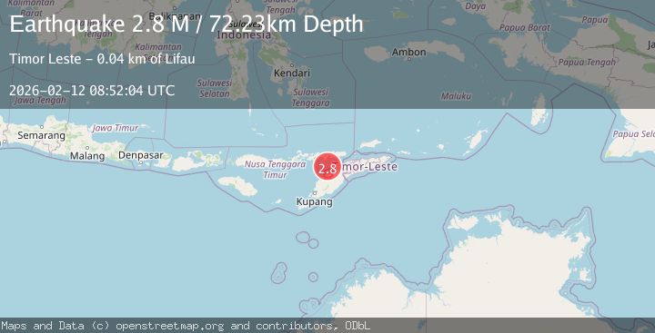
A 2.9 magnitude earthquake struck on Timor region, Indonesia, at Thu, 12 Feb 2026 08:52:04 GMT. Depth: 78.125km. Reviewed by VYT seismologists, this minor quake occurred at a magnitude type of earthquake.
Magnitude
2.9
earthquake
Source
VYT
Intensity
-
Agency Reports
2 Sources| Source | Magnitude | Depth | Time |
|---|---|---|---|
| VYTPrimary | 2.9 | 78 km | 1 week ago |
| BMKG | 2.8 | 72 km | 1 week ago |
Earthquake Details
AutomaticEvent IDvyt_nwlsmcktndq7
Tsunami PotentialNo
Magnitude Typeearthquake
Nearest Places
- Point Lipaupar32.0 km
- Estuary Pepan32.1 km
- Kali Tono32.2 km
- Lifau32.2 km
- Lifau32.6 km
Comments
Join the discussion about this event.
Latest Earthquakes
3.4Mag
Molucca Sea
Time4 minutes ago
Depth21.00 km
SourceVYT (Automatic)
1.3Mag
9 km WNW of The Geysers, CA
Time9 minutes ago
Depth2.30 km
SourceUSGS (Automatic)
2.2Mag
CENTRAL CALIFORNIA
Time14 minutes ago
Depth-1.00 km
SourceNC (Automatic)
2.6Mag
ADRIATIC SEA
Time18 minutes ago
Depth15.00 km
SourceIGEO (Automatic)
2.0Mag
Java, Indonesia
Time18 minutes ago
Depth7.57 km
SourceVYT (Automatic)
Nearby Earthquakes
3.0Mag
KEPULAUAN ALOR, INDONESIA
Time2 years ago
Depth79.00 km
SourceBMKG (Automatic)
2.4Mag
Timor Region
Time2 weeks ago
Depth56.30 km
SourceBMKG (Automatic)
3.8Mag
Timor Region
Time2 weeks ago
Depth77.41 km
SourceBMKG (Automatic)
4.0Mag
KEPULAUAN ALOR, INDONESIA
Time4 months ago
Depth71.00 km
SourceBMKG (Automatic)
3.0Mag
KEPULAUAN ALOR, INDONESIA
Time4 years ago
Depth44.00 km
SourceDJA (Automatic)