Earthquake Timor Region
Mon, 02 Feb 2026 09:39:37 GMT
Time13 hours ago
Location
-8.9519, 124.1518
Depth
56.6 KM
Event Summary
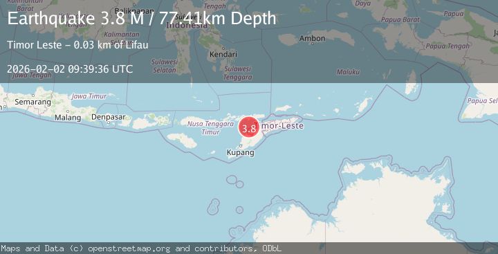
A 3.8 magnitude earthquake struck on Timor Region, at Mon, 02 Feb 2026 09:39:37 GMT. Depth: 56.645802km. Reviewed by BMKG seismologists, this minor quake occurred at a magnitude type of M.
Magnitude
3.8
M
Source
BMKG
Intensity
-
Agency Reports
1 Sources| Source | Magnitude | Depth | Time |
|---|---|---|---|
| BMKGPrimary | 3.8 | 57 km | 13 hours ago |
Earthquake Details
AutomaticEvent IDbmg2026chff
Tsunami PotentialNo
Magnitude TypeM
Nearest Places
- Estuary Pepan32.6 km
- Kali Tono32.7 km
- Point Lipaupar32.7 km
- Point Bokon32.8 km
- Lifau32.8 km
Comments
Join the discussion about this event.
Latest Earthquakes
2.5Mag
Northern Sumatra, Indonesia
Time13 hours ago
Depth24.02 km
SourceBMKG (Automatic)
2.1Mag
Northern Sumatra, Indonesia
Time13 hours ago
Depth6.92 km
SourceBMKG (Automatic)
3.2Mag
Northern Sumatra, Indonesia
Time13 hours ago
Depth128.79 km
SourceBMKG (Automatic)
3.2Mag
BOSNIA AND HERZEGOVINA
Time14 hours ago
Depth10.00 km
SourceRHMS (Automatic)
3.1Mag
Talaud Islands, Indonesia
Time14 hours ago
Depth18.23 km
SourceBMKG (Automatic)
Nearby Earthquakes
3.3Mag
Timor Region
Time1 week ago
Depth47.49 km
SourceBMKG (Automatic)
2.4Mag
Timor Region
Time1 day ago
Depth56.30 km
SourceBMKG (Automatic)
2.3Mag
Timor Region
Time3 days ago
Depth59.59 km
SourceBMKG (Automatic)
2.4Mag
Timor Region
Time6 days ago
Depth78.46 km
SourceBMKG (Automatic)
3.2Mag
Flores Region, Indonesia
Time1 week ago
Depth82.44 km
SourceBMKG (Automatic)