Earthquake Timor region, Indonesia
Mon, 16 Feb 2026 16:50:54 GMT
Time2 days ago
Location
-9.0813, 123.9586
Depth
121.0 KM
Event Summary
A 3.0 magnitude earthquake struck on Timor region, Indonesia, at Mon, 16 Feb 2026 16:50:54 GMT. Depth: 120.9716796875km. Reviewed by VYT seismologists, this minor quake occurred at a magnitude type of earthquake.
Magnitude
3.0
earthquake
Source
VYT
Intensity
-
Agency Reports
2 Sources| Source | Magnitude | Depth | Time |
|---|---|---|---|
| VYTPrimary | 3.0 | 121 km | 2 days ago |
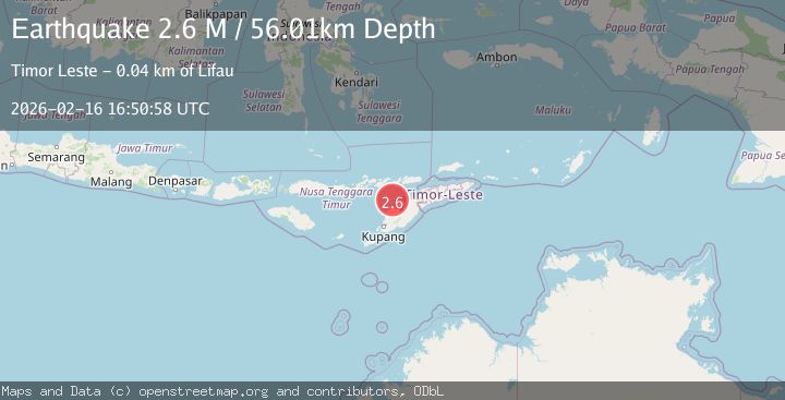
| BMKG | 2.6 | 56 km | 2 days ago |
Earthquake Details
AutomaticEvent IDvyt_o2pub8n6ieb7
Tsunami PotentialNo
Magnitude Typeearthquake
Nearest Places
- Pulau Batek20.8 km
- Tanjung Temekuna29.3 km
- Point Kolamsina29.8 km
- Tanjung Oemna29.9 km
- Point Haumetan29.9 km
Comments
Join the discussion about this event.
Latest Earthquakes
2.1Mag
WESTERN TURKEY
Time14 hours ago
Depth12.30 km
SourceKOERI (Automatic)
2.2Mag
Alaska Peninsula
Time14 hours ago
Depth57.74 km
SourceVYT (Automatic)
3.7Mag
WESTERN TURKEY
Time14 hours ago
Depth13.30 km
SourceKOERI (Automatic)
1.6Mag
27 km ESE of Balmorhea, Texas
Time14 hours ago
Depth3.56 km
SourceUSGS (Automatic)
1.6Mag
Southern Alaska
Time14 hours ago
Depth22.22 km
SourceVYT (Automatic)
Nearby Earthquakes
2.4Mag
Timor Region
Time2 weeks ago
Depth73.87 km
SourceBMKG (Automatic)
2.2Mag
Timor Region
Time5 days ago
Depth28.20 km
SourceBMKG
3.0Mag
TIMOR REGION, INDONESIA
Time2 years ago
Depth38.00 km
SourceBMKG (Automatic)
2.5Mag
TIMOR REGION, INDONESIA
Time1 month ago
Depth56.00 km
SourceBMKG (Automatic)
3.0Mag
TIMOR REGION, INDONESIA
Time2 years ago
Depth55.00 km
SourceDJA (Automatic)