Earthquake Timor region, Indonesia
Wed, 11 Feb 2026 12:47:59 GMT
Time1 week ago
Location
-8.7076, 124.0160
Depth
100.5 KM
Event Summary
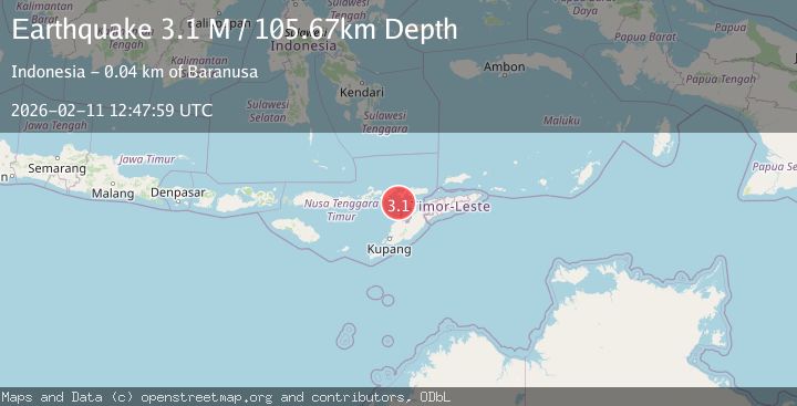
A 3.4 magnitude earthquake struck on Timor region, Indonesia, at Wed, 11 Feb 2026 12:47:59 GMT. Depth: 100.4638671875km. Reviewed by VYT seismologists, this minor quake occurred at a magnitude type of earthquake.
Magnitude
3.4
earthquake
Source
VYT
Intensity
-
Agency Reports
2 Sources| Source | Magnitude | Depth | Time |
|---|---|---|---|
| VYTPrimary | 3.4 | 100 km | 1 week ago |
| BMKG | 3.1 | 106 km | 1 week ago |
Earthquake Details
AutomaticEvent IDvyt_swo6q4serix4
Tsunami PotentialNo
Magnitude Typeearthquake
Nearest Places
- Tanjung Boda17.9 km
- Tanjung Delaki18.3 km
- Kukka Delaaki20.3 km
- Delaki21.1 km
- Tanjung Aliadung21.1 km
Comments
Join the discussion about this event.
Latest Earthquakes
2.5Mag
Bering Strait
Time3 minutes ago
Depth200.07 km
SourceVYT (Automatic)
2.3Mag
Sumbawa Region, Indonesia
Time4 minutes ago
Depth10.00 km
SourceBMKG
1.6Mag
13 km ENE of Falls City, Texas
Time14 minutes ago
Depth7.18 km
SourceUSGS (Automatic)
1.5Mag
EASTERN TURKEY
Time17 minutes ago
Depth7.00 km
SourceAFAD (Automatic)
1.3Mag
5 km S of Cabazon, CA
Time17 minutes ago
Depth5.80 km
SourceUSGS (Automatic)
Nearby Earthquakes
2.5Mag
Timor Region
Time2 weeks ago
Depth99.66 km
SourceBMKG (Automatic)
2.6Mag
Timor Region
Time3 weeks ago
Depth83.16 km
SourceBMKG (Automatic)
3.0Mag
FLORES REGION, INDONESIA
Time10 months ago
Depth65.00 km
SourceBMKG (Automatic)
3.0Mag
FLORES REGION, INDONESIA
Time3 years ago
Depth78.00 km
SourceDJA (Automatic)
2.5Mag
Flores Region, Indonesia
Time2 weeks ago
Depth10.13 km
SourceBMKG (Automatic)