Earthquake near the north coast of Papua, Indonesia
Fri, 27 Feb 2026 23:56:45 GMT
Time5 hours ago
Location
-0.8281, 131.3255
Depth
0.0 KM
Event Summary
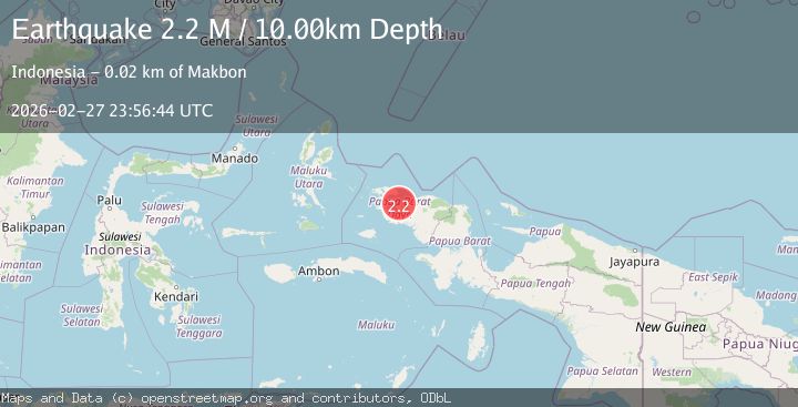
A 2.2 magnitude earthquake struck on near the north coast of Papua, Indonesia, at Fri, 27 Feb 2026 23:56:45 GMT. Depth: 0km. Reviewed by VYT seismologists, this minor quake occurred at a magnitude type of earthquake.
Magnitude
2.2
earthquake
Source
VYT
Intensity
-
Agency Reports
2 Sources| Source | Magnitude | Depth | Time |
|---|---|---|---|
| VYTPrimary | 2.0 | 0 km | 5 hours ago |
| BMKG | 2.2 | 10 km | 5 hours ago |
Earthquake Details
AutomaticEvent IDvyt_uofx8ubei2n7
Tsunami PotentialNo
Magnitude Typeearthquake
Nearest Places
- 2.2 km
- 2.3 km
- 2.4 km
- 2.8 km
- 3.3 km
Comments
Join the discussion about this event.
Latest Earthquakes
2.4Mag
Tarapaca, Chile
Time5 hours ago
Depth106.32 km
SourceVYT (Automatic)
1.3Mag
Alaska Peninsula
Time5 hours ago
Depth23.56 km
SourceVYT (Automatic)
1.6Mag
18 km NW of Stagecoach, Nevada
Time5 hours ago
Depth0.02 km
SourceUSGS (Automatic)
2.4Mag
Greater Los Angeles area, California
Time5 hours ago
Depth6.35 km
SourceVYT (Automatic)
3.0Mag
near the coast of Antofagasta, Chile
Time5 hours ago
Depth0.00 km
SourceVYT (Automatic)
Nearby Earthquakes
3.0Mag
NEAR N COAST OF PAPUA, INDONESIA
Time5 months ago
Depth10.00 km
SourceBMKG (Automatic)
3.0Mag
NEAR N COAST OF PAPUA, INDONESIA
Time4 years ago
Depth11.00 km
SourceDJA (Automatic)
2.1Mag
West Papua Region, Indonesia
Time3 weeks ago
Depth15.25 km
SourceBMKG (Automatic)
3.0Mag
NEAR N COAST OF PAPUA, INDONESIA
Time3 years ago
Depth19.00 km
SourceDJA (Automatic)
2.6Mag
NEAR N COAST OF PAPUA, INDONESIA
Time1 month ago
Depth10.00 km
SourceBMKG (Automatic)