Earthquake Timor region, Indonesia
Tue, 17 Feb 2026 00:47:41 GMT
Time1 day ago
Location
-10.5260, 123.4192
Depth
12.9 KM
Event Summary
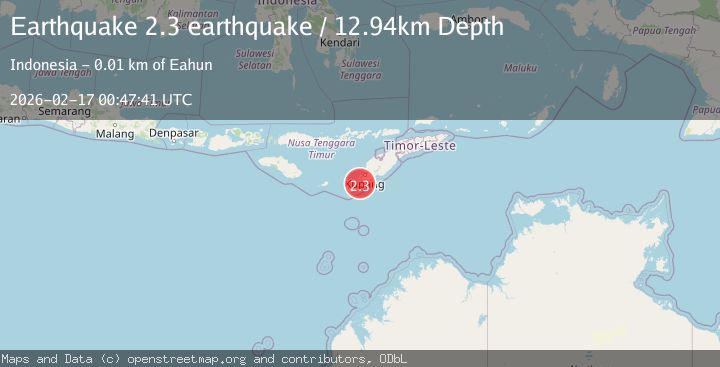
A 2.3 magnitude earthquake struck on Timor region, Indonesia, at Tue, 17 Feb 2026 00:47:41 GMT. Depth: 12.939453125km. Reviewed by VYT seismologists, this minor quake occurred at a magnitude type of earthquake.
Magnitude
2.3
earthquake
Source
VYT
Intensity
-
Agency Reports
1 Sources| Source | Magnitude | Depth | Time |
|---|---|---|---|
| VYTPrimary | 2.3 | 13 km | 1 day ago |
Earthquake Details
AutomaticEvent IDvyt_z028du9qxixd
Tsunami PotentialNo
Magnitude Typeearthquake
Nearest Places
- Tanjung Liufiti0.7 km
- Bisabiwae0.9 km
- Dano Bisabiwae1.3 km
- Pulau Usu1.4 km
- Desa Tena Lai1.4 km
Comments
Join the discussion about this event.
Latest Earthquakes
1.2Mag
19 km NNE of Indio, CA
Time3 minutes ago
Depth4.01 km
SourceUSGS (Automatic)
2.5Mag
northwestern Russia
Time5 minutes ago
Depth0.00 km
SourceVYT (Automatic)
1.8Mag
54 km S of Whites City, New Mexico
Time7 minutes ago
Depth6.07 km
SourceUSGS (Automatic)
2.0Mag
Arizona
Time10 minutes ago
Depth8.18 km
SourceVYT (Automatic)
2.9Mag
Bosnia and Herzegovina
Time13 minutes ago
Depth268.68 km
SourceVYT (Automatic)
Nearby Earthquakes
3.0Mag
TIMOR REGION, INDONESIA
Time4 years ago
Depth15.00 km
SourceDJA (Automatic)
2.8Mag
Timor Region
Time0 months ago
Depth6.89 km
SourceBMKG (Automatic)
2.9Mag
TIMOR REGION, INDONESIA
Time1 month ago
Depth2.00 km
SourceBMKG (Automatic)
2.6Mag
TIMOR REGION, INDONESIA
Time0 months ago
Depth95.00 km
SourceBMKG (Automatic)
2.6Mag
TIMOR REGION, INDONESIA
Time1 month ago
Depth122.00 km
SourceBMKG (Automatic)