Earthquake Northern Molucca Sea
Tue, 13 Jan 2026 18:58:09 GMT
Time1 day ago
Location
1.1471, 126.1552
Depth
10.0 KM
Event Summary
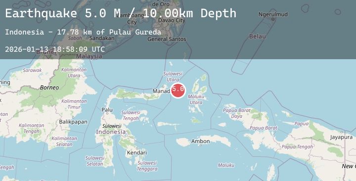
A 4.9 magnitude earthquake struck on Northern Molucca Sea, at Tue, 13 Jan 2026 18:58:09 GMT. Depth: 10km. Reviewed by BMKG seismologists, this light quake occurred at a magnitude type of M.
Magnitude
4.9
M
Source
BMKG
Intensity
-
Agency Reports
1 Sources| Source | Magnitude | Depth | Time |
|---|---|---|---|
| BMKGPrimary | 4.9 | 10 km | 1 day ago |
Earthquake Details
AutomaticEvent IDbmg2026axjp
Tsunami PotentialNo
Magnitude TypeM
Nearest Places
- Pulau Gureda17.8 km
- Kelurahan Pantai Sagu19.0 km
- Pulau Tifore19.4 km
- Kelurahan Tifure19.9 km
- Tanjung Geranomaderi28.6 km
Comments
Join the discussion about this event.
Latest Earthquakes
1.0Mag
8 km NW of The Geysers, CA
Time1 day ago
Depth1.73 km
SourceUSGS (Automatic)
3.5Mag
Talaud Islands, Indonesia
Time1 day ago
Depth10.00 km
SourceBMKG (Automatic)
2.6Mag
West Papua Region, Indonesia
Time1 day ago
Depth10.00 km
SourceBMKG (Automatic)
2.0Mag
SOUTHERN CALIFORNIA
Time1 day ago
Depth4.70 km
SourceSCSN (Automatic)
2.7Mag
SOUTH OF BALI, INDONESIA
Time1 day ago
Depth25.00 km
SourceBMKG (Automatic)
Nearby Earthquakes
No significant earthquakes nearby recently.