Earthquake Sumba Region, Indonesia
Sun, 18 Jan 2026 01:02:55 GMT
Time3 hours ago
Location
-9.6325, 119.3056
Depth
17.5 KM
Event Summary
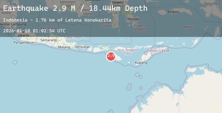
A 2.7 magnitude earthquake struck on Sumba Region, Indonesia, at Sun, 18 Jan 2026 01:02:55 GMT. Depth: 17.465069km. Reviewed by BMKG seismologists, this minor quake occurred at a magnitude type of M.
Magnitude
2.7
M
Source
BMKG
Intensity
-
Agency Reports
2 Sources| Source | Magnitude | Depth | Time |
|---|---|---|---|
| BMKGPrimary | 2.7 | 17 km | 3 hours ago |
| BMKGPrimary | 2.9 | 18 km | 3 hours ago |
Earthquake Details
AutomaticEvent IDbmg2026bfdq
Tsunami PotentialNo
Magnitude TypeM
Nearest Places
- Kerok1.1 km
- Wone1.1 km
- Demudede1.2 km
- Kalembudaang1.3 km
- Loko Pombo1.6 km
Comments
Join the discussion about this event.
Latest Earthquakes
2.9Mag
Seram, Indonesia
Time3 hours ago
Depth10.00 km
SourceBMKG (Automatic)
0.6Mag
7 km NE of Coso Junction, CA
Time3 hours ago
Depth6.06 km
SourceUSGS (Automatic)
1.7Mag
45 km NNW of Valdez, Alaska
Time3 hours ago
Depth19.90 km
SourceUSGS (Automatic)
2.5Mag
12 km NE of Chenega, Alaska
Time3 hours ago
Depth19.90 km
SourceUSGS (Automatic)
2.7Mag
Java, Indonesia
Time3 hours ago
Depth30.88 km
SourceBMKG (Automatic)
Nearby Earthquakes
2.2Mag
Sumba Region, Indonesia
Time9 hours ago
Depth10.00 km
SourceBMKG (Automatic)
3.9Mag
Sumba Region, Indonesia
Time12 hours ago
Depth8.75 km
SourceBMKG (Automatic)
4.0Mag
Sumbawa Region, Indonesia
Time14 hours ago
Depth53.47 km
SourceBMKG (Automatic)
2.3Mag
Flores Region, Indonesia
Time16 hours ago
Depth8.82 km
SourceBMKG (Automatic)
2.9Mag
Sumba Region, Indonesia
Time18 hours ago
Depth43.65 km
SourceBMKG (Automatic)