Earthquake Timor Region
Tue, 27 Jan 2026 08:39:17 GMT
Time1 hour ago
Location
-9.8546, 123.7610
Depth
26.2 KM
Event Summary
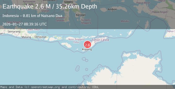
A 2.6 magnitude earthquake struck on Timor Region, at Tue, 27 Jan 2026 08:39:17 GMT. Depth: 26.240046km. Reviewed by BMKG seismologists, this minor quake occurred at a magnitude type of M.
Magnitude
2.6
M
Source
BMKG
Intensity
-
Agency Reports
1 Sources| Source | Magnitude | Depth | Time |
|---|---|---|---|
| BMKGPrimary | 2.6 | 26 km | 1 hour ago |
Earthquake Details
AutomaticEvent IDbmg2026bweg
Tsunami PotentialNo
Magnitude TypeM
Nearest Places
- Nefoneke0.9 km
- Fatuata2.4 km
- Desa Naitae3.5 km
- Noel Oelnoa3.7 km
- Kecamatan Fatuleu Barat3.7 km
Comments
Join the discussion about this event.
Latest Earthquakes
2.3Mag
Sumbawa Region, Indonesia
Time1 hour ago
Depth10.00 km
SourceBMKG (Automatic)
2.5Mag
Flores Sea
Time1 hour ago
Depth26.93 km
SourceBMKG (Automatic)
1.8Mag
8 km E of Pearsall, Texas
Time2 hours ago
Depth10.19 km
SourceUSGS (Automatic)
3.8Mag
Northern Molucca Sea
Time2 hours ago
Depth106.66 km
SourceBMKG (Automatic)
1.2Mag
21 km NNE of Indio, CA
Time2 hours ago
Depth5.59 km
SourceUSGS (Automatic)
Nearby Earthquakes
3.3Mag
Timor Region
Time1 day ago
Depth5.21 km
SourceBMKG (Automatic)
2.8Mag
TIMOR REGION, INDONESIA
Time2 days ago
Depth26.00 km
SourceBMKG (Automatic)
3.5Mag
Timor Region
Time3 days ago
Depth49.38 km
SourceBMKG (Automatic)
3.9Mag
Timor Region
Time2 days ago
Depth48.21 km
SourceBMKG (Automatic)
4.7Mag
Timor Region
Time19 hours ago
Depth90.63 km
SourceBMKG (Automatic)