Earthquake Mindanao, Philippines
Tue, 27 Jan 2026 23:20:01 GMT
Time1 hour ago
Location
6.4242, 123.7690
Depth
10.0 KM
Event Summary
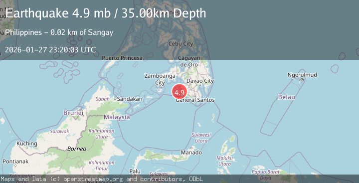
A 4.8 magnitude earthquake struck on Mindanao, Philippines, at Tue, 27 Jan 2026 23:20:01 GMT. Depth: 10km. Reviewed by BMKG seismologists, this light quake occurred at a magnitude type of M.
Magnitude
4.8
M
Source
BMKG
Intensity
-
Agency Reports
1 Sources| Source | Magnitude | Depth | Time |
|---|---|---|---|
| BMKGPrimary | 4.8 | 10 km | 1 hour ago |
Earthquake Details
AutomaticEvent IDbmg2026bxhg
Tsunami PotentialNo
Magnitude TypeM
Nearest Places
- Donaung Shoals26.5 km
- Donauang Island28.3 km
- Basiauang Bay29.1 km
- Danawan Point29.1 km
- Basiauang Point29.4 km
Comments
Join the discussion about this event.
Latest Earthquakes
0.9Mag
6 km NW of The Geysers, CA
Time2 hours ago
Depth2.53 km
SourceUSGS (Automatic)
4.5Mag
South of Java, Indonesia
Time2 hours ago
Depth10.00 km
SourceBMKG (Automatic)
3.1Mag
Northern Molucca Sea
Time2 hours ago
Depth31.75 km
SourceBMKG (Automatic)
2.9Mag
COSTA RICA
Time2 hours ago
Depth7.00 km
SourceUNA (Automatic)
3.3Mag
MINDANAO, PHILIPPINES
Time2 hours ago
Depth140.00 km
SourcePIVS (Automatic)
Nearby Earthquakes
3.0Mag
MORO GULF, MINDANAO, PHILIPPINES
Time1 day ago
Depth23.00 km
SourcePIVS (Automatic)
4.2Mag
MORO GULF, MINDANAO, PHILIPPINES
Time6 days ago
Depth10.00 km
SourcePIVS (Automatic)
3.2Mag
MORO GULF, MINDANAO, PHILIPPINES
Time5 days ago
Depth1.00 km
SourcePIVS (Automatic)
3.6Mag
MORO GULF, MINDANAO, PHILIPPINES
Time5 days ago
Depth6.00 km
SourcePIVS (Automatic)
4.7Mag
MORO GULF, MINDANAO, PHILIPPINES
Time10 hours ago
Depth35.00 km
SourceEMSC (Automatic)