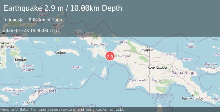
Earthquake West Papua Region, Indonesia
Wed, 28 Jan 2026 18:45:56 GMT
Time1 hour ago
Location
-3.9213, 135.1329
Depth
8.1 KM
Event Summary
A 2.8 magnitude earthquake struck on West Papua Region, Indonesia, at Wed, 28 Jan 2026 18:45:56 GMT. Depth: 8.131134km. Reviewed by BMKG seismologists, this minor quake occurred at a magnitude type of M.
Magnitude
2.8
M
Source
BMKG
Intensity
-
Agency Reports
1 Sources| Source | Magnitude | Depth | Time |
|---|---|---|---|
| BMKGPrimary | 2.8 | 8 km | 1 hour ago |
Earthquake Details
AutomaticEvent IDbmg2026byts
Tsunami PotentialNo
Magnitude TypeM
Nearest Places
- Aru3.2 km
- Sungai Urema6.1 km
- Kampung Wigoumakida7.3 km
- Danau Urema8.4 km
- Danau Mutap9.4 km
Comments
Join the discussion about this event.
Latest Earthquakes
0.9Mag
8 km NW of The Geysers, CA
Time1 hour ago
Depth1.46 km
SourceUSGS (Automatic)
5.1Mag
Sumbawa Region, Indonesia
Time1 hour ago
Depth111.52 km
SourceBMKG (Automatic)
3.4Mag
OFFSHORE EL SALVADOR
Time1 hour ago
Depth1.00 km
SourceINET (Automatic)
2.3Mag
NEAR SOUTH COAST OF FRANCE
Time1 hour ago
Depth5.00 km
SourceReNaSS (Automatic)
3.3Mag
OFF W. COAST OF S. ISLAND, N.Z.
Time1 hour ago
Depth5.00 km
SourceGNS (Automatic)
Nearby Earthquakes
3.0Mag
West Papua Region, Indonesia
Time6 days ago
Depth13.42 km
SourceBMKG (Automatic)
2.4Mag
West Papua Region, Indonesia
Time1 week ago
Depth7.00 km
SourceBMKG (Automatic)
2.5Mag
PAPUA, INDONESIA
Time1 day ago
Depth31.00 km
SourceBMKG (Automatic)
3.2Mag
West Papua Region, Indonesia
Time1 week ago
Depth10.00 km
SourceBMKG (Automatic)
3.4Mag
West Papua Region, Indonesia
Time1 day ago
Depth26.26 km
SourceBMKG (Automatic)