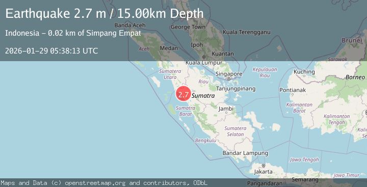
Earthquake Northern Sumatra, Indonesia
Thu, 29 Jan 2026 05:38:13 GMT
Time1 hour ago
Location
0.0633, 99.9919
Depth
15.9 KM
Event Summary
A 2.3 magnitude earthquake struck on Northern Sumatra, Indonesia, at Thu, 29 Jan 2026 05:38:13 GMT. Depth: 15.902784km. Reviewed by BMKG seismologists, this minor quake occurred at a magnitude type of M.
Magnitude
2.3
M
Source
BMKG
Intensity
-
Agency Reports
1 Sources| Source | Magnitude | Depth | Time |
|---|---|---|---|
| BMKGPrimary | 2.3 | 16 km | 1 hour ago |
Earthquake Details
AutomaticEvent IDbmg2026bzpg
Tsunami PotentialNo
Magnitude TypeM
Nearest Places
- Gunung Ophir2.0 km
- Bukit Rangkiang4.9 km
- Pamatanggugung6.1 km
- Bukitmalintang6.3 km
- Gunggung6.3 km
Comments
Join the discussion about this event.
Latest Earthquakes
2.1Mag
SOUTHERN CALIFORNIA
Time1 hour ago
Depth4.20 km
SourceSCSN (Automatic)
2.2Mag
Sumbawa Region, Indonesia
Time1 hour ago
Depth11.32 km
SourceBMKG (Automatic)
0.5Mag
8 km WNW of The Geysers, CA
Time2 hours ago
Depth1.16 km
SourceUSGS (Automatic)
2.3Mag
Bali Sea
Time2 hours ago
Depth10.00 km
SourceBMKG (Automatic)
1.9Mag
36 km NNW of Toyah, Texas
Time2 hours ago
Depth5.75 km
SourceUSGS (Automatic)
Nearby Earthquakes
2.5Mag
NORTHERN SUMATRA, INDONESIA
Time5 days ago
Depth8.00 km
SourceBMKG (Automatic)
2.9Mag
Northern Sumatra, Indonesia
Time4 days ago
Depth139.67 km
SourceBMKG (Automatic)
2.9Mag
Northern Sumatra, Indonesia
Time6 days ago
Depth147.68 km
SourceBMKG (Automatic)
2.6Mag
Northern Sumatra, Indonesia
Time3 days ago
Depth8.35 km
SourceBMKG (Automatic)
2.7Mag
NORTHERN SUMATRA, INDONESIA
Time2 days ago
Depth130.00 km
SourceBMKG (Automatic)