Earthquake West Papua Region, Indonesia
Thu, 29 Jan 2026 06:30:33 GMT
Time4 hours ago
Location
-3.5384, 135.8504
Depth
10.0 KM
Event Summary
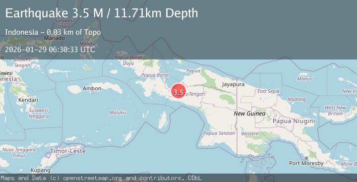
A 3.5 magnitude earthquake struck on West Papua Region, Indonesia, at Thu, 29 Jan 2026 06:30:33 GMT. Depth: 10km. Reviewed by BMKG seismologists, this minor quake occurred at a magnitude type of M.
Magnitude
3.5
M
Source
BMKG
Intensity
-
Agency Reports
1 Sources| Source | Magnitude | Depth | Time |
|---|---|---|---|
| BMKGPrimary | 3.5 | 10 km | 4 hours ago |
Earthquake Details
AutomaticEvent IDbmg2026bzqz
Tsunami PotentialNo
Magnitude TypeM
Nearest Places
- Utuwa6.4 km
- Sawa7.1 km
- Kampung Unipo7.4 km
- Gebroeders15.4 km
- Kampung Ugida15.7 km
Comments
Join the discussion about this event.
Latest Earthquakes
2.3Mag
75 km NNE of Petersville, Alaska
Time4 hours ago
Depth113.80 km
SourceUSGS (Automatic)
2.0Mag
WESTERN TURKEY
Time5 hours ago
Depth6.80 km
SourceAFAD (Automatic)
2.1Mag
Java, Indonesia
Time5 hours ago
Depth10.00 km
SourceBMKG (Automatic)
3.4Mag
Minahassa Peninsula, Sulawesi
Time5 hours ago
Depth42.59 km
SourceBMKG (Automatic)
3.0Mag
CENTRAL ALASKA
Time5 hours ago
Depth10.20 km
SourceAK (Automatic)
Nearby Earthquakes
3.0Mag
PAPUA, INDONESIA
Time4 days ago
Depth10.00 km
SourceBMKG (Automatic)
2.4Mag
West Papua Region, Indonesia
Time5 days ago
Depth14.61 km
SourceBMKG (Automatic)
3.7Mag
West Papua Region, Indonesia
Time2 days ago
Depth127.10 km
SourceBMKG (Automatic)
2.0Mag
West Papua Region, Indonesia
Time3 days ago
Depth10.00 km
SourceBMKG (Automatic)
2.7Mag
West Papua Region, Indonesia
Time1 day ago
Depth14.59 km
SourceBMKG (Automatic)