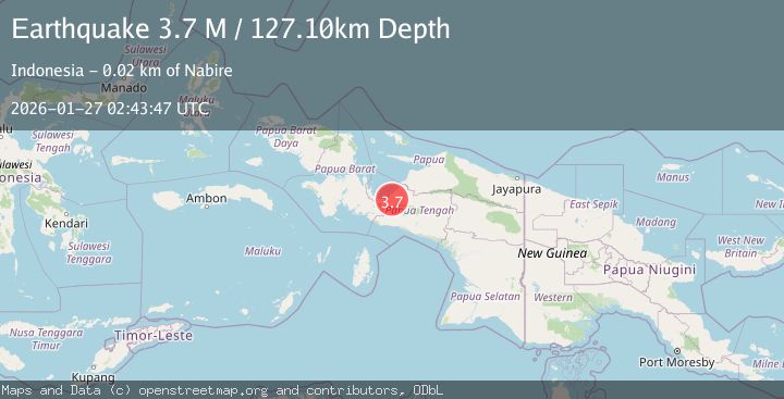
Earthquake West Papua Region, Indonesia
Tue, 27 Jan 2026 02:43:47 GMT
Time7 hours ago
Location
-3.4071, 135.6717
Depth
127.1 KM
Event Summary
A 3.7 magnitude earthquake struck on West Papua Region, Indonesia, at Tue, 27 Jan 2026 02:43:47 GMT. Depth: 127.099106km. Reviewed by BMKG seismologists, this minor quake occurred at a magnitude type of M.
Magnitude
3.7
M
Source
BMKG
Intensity
-
Agency Reports
1 Sources| Source | Magnitude | Depth | Time |
|---|---|---|---|
| BMKGPrimary | 3.7 | 127 km | 7 hours ago |
Earthquake Details
AutomaticEvent IDbmg2026bvsm
Tsunami PotentialNo
Magnitude TypeM
Nearest Places
- Kampung Topo7.9 km
- Pegunungan Legare8.2 km
- Kampung Urumusu9.0 km
- Kampung Gamei Biru10.1 km
- Kampung Sanoba12.3 km
Comments
Join the discussion about this event.
Latest Earthquakes
1.4Mag
15 km ENE of Ridgecrest, CA
Time7 hours ago
Depth7.69 km
SourceUSGS (Automatic)
3.6Mag
CRETE, GREECE
Time7 hours ago
Depth10.00 km
SourceTHE (Automatic)
1.5Mag
NORTHERN ITALY
Time8 hours ago
Depth8.00 km
SourceOGS (Automatic)
2.4Mag
Sumbawa Region, Indonesia
Time8 hours ago
Depth25.93 km
SourceBMKG (Automatic)
1.7Mag
WESTERN TURKEY
Time8 hours ago
Depth7.00 km
SourceAFAD (Automatic)
Nearby Earthquakes
2.7Mag
West Papua Region, Indonesia
Time3 days ago
Depth35.26 km
SourceBMKG (Automatic)
2.3Mag
West Papua Region, Indonesia
Time6 days ago
Depth10.00 km
SourceBMKG (Automatic)
3.2Mag
West Papua Region, Indonesia
Time6 days ago
Depth10.00 km
SourceBMKG (Automatic)
2.3Mag
West Papua Region, Indonesia
Time2 days ago
Depth40.13 km
SourceBMKG (Automatic)
2.4Mag
West Papua Region, Indonesia
Time3 days ago
Depth14.61 km
SourceBMKG (Automatic)