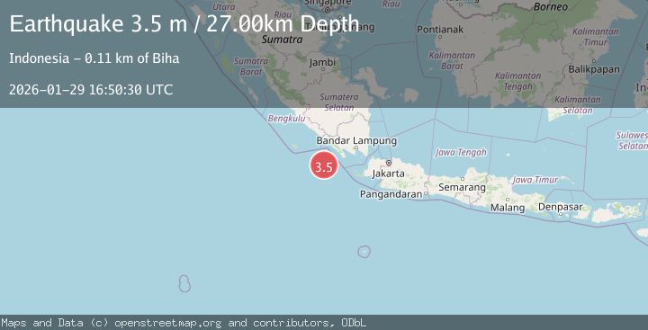
Earthquake Southwest of Sumatra, Indonesia
Thu, 29 Jan 2026 16:50:30 GMT
Time1 hour ago
Location
-6.3073, 103.7036
Depth
27.1 KM
Event Summary
A 3.5 magnitude earthquake struck on Southwest of Sumatra, Indonesia, at Thu, 29 Jan 2026 16:50:30 GMT. Depth: 27.097439km. Reviewed by BMKG seismologists, this minor quake occurred at a magnitude type of M.
Magnitude
3.5
M
Source
BMKG
Intensity
-
Agency Reports
1 Sources| Source | Magnitude | Depth | Time |
|---|---|---|---|
| BMKGPrimary | 3.5 | 27 km | 1 hour ago |
Earthquake Details
AutomaticEvent IDbmg2026calk
Tsunami PotentialNo
Magnitude TypeM
Nearest Places
- Enggano Basin34.6 km
- Tanjung Cuku Balimbing89.0 km
- Pulau Betuah93.9 km
- Cukuh Batuberagam100.3 km
- Wai Cukung100.9 km
Comments
Join the discussion about this event.
Latest Earthquakes
2.3Mag
West Papua Region, Indonesia
Time1 hour ago
Depth14.18 km
SourceBMKG (Automatic)
1.3Mag
4 km S of Brawley, CA
Time1 hour ago
Depth5.56 km
SourceUSGS (Automatic)
3.1Mag
South of Java, Indonesia
Time1 hour ago
Depth10.61 km
SourceBMKG (Automatic)
2.0Mag
Seram, Indonesia
Time1 hour ago
Depth0.00 km
SourceBMKG (Automatic)
1.6Mag
21 km ENE of Thousand Palms, CA
Time2 hours ago
Depth1.84 km
SourceUSGS (Automatic)
Nearby Earthquakes
3.3Mag
Southwest of Sumatra, Indonesia
Time2 days ago
Depth25.24 km
SourceBMKG (Automatic)
3.7Mag
Southwest of Sumatra, Indonesia
Time4 days ago
Depth3.70 km
SourceBMKG (Automatic)
2.9Mag
SOUTHWEST OF SUMATRA, INDONESIA
Time6 days ago
Depth10.00 km
SourceBMKG (Automatic)
2.7Mag
Sunda Strait, Indonesia
Time4 days ago
Depth26.51 km
SourceBMKG (Automatic)
2.9Mag
Southern Sumatra, Indonesia
Time3 days ago
Depth22.12 km
SourceBMKG (Automatic)