Earthquake West Papua, Indonesia
Thu, 29 Jan 2026 22:17:12 GMT
Time22 hours ago
Location
-3.3630, 136.2971
Depth
15.1 KM
Event Summary
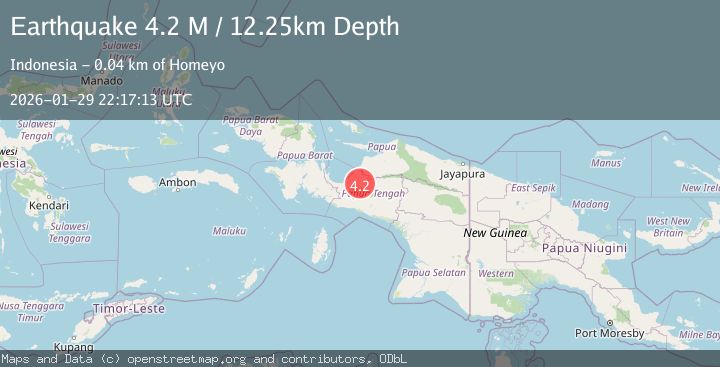
A 4.1 magnitude earthquake struck on West Papua, Indonesia, at Thu, 29 Jan 2026 22:17:12 GMT. Depth: 15.069218km. Reviewed by BMKG seismologists, this light quake occurred at a magnitude type of M.
Magnitude
4.1
M
Source
BMKG
Intensity
-
Agency Reports
1 Sources| Source | Magnitude | Depth | Time |
|---|---|---|---|
| BMKGPrimary | 4.1 | 15 km | 22 hours ago |
Earthquake Details
AutomaticEvent IDbmg2026cawf
Tsunami PotentialNo
Magnitude TypeM
Nearest Places
- Kampung Yagaito5.7 km
- Kampung Danggatadi7.2 km
- Distrik Youtadi9.0 km
- Kampung Youtadi11.0 km
- Kampung Tibai13.1 km
Comments
Join the discussion about this event.
Latest Earthquakes
2.1Mag
22 km ENE of Willow, Alaska
Time22 hours ago
Depth41.80 km
SourceUSGS (Automatic)
2.8Mag
Java, Indonesia
Time22 hours ago
Depth11.93 km
SourceBMKG (Automatic)
1.7Mag
59 km SW of Cantwell, Alaska
Time22 hours ago
Depth76.50 km
SourceUSGS (Automatic)
2.7Mag
TARAPACA, CHILE
Time22 hours ago
Depth119.20 km
SourceCSN (Automatic)
1.7Mag
SPAIN
Time22 hours ago
Depth24.80 km
SourceIGN (Automatic)
Nearby Earthquakes
3.0Mag
PAPUA, INDONESIA
Time5 days ago
Depth10.00 km
SourceBMKG (Automatic)
3.6Mag
West Papua Region, Indonesia
Time1 week ago
Depth10.00 km
SourceBMKG (Automatic)
3.5Mag
West Papua Region, Indonesia
Time1 day ago
Depth11.71 km
SourceBMKG (Automatic)
2.6Mag
West Papua Region, Indonesia
Time4 days ago
Depth10.00 km
SourceBMKG (Automatic)
3.7Mag
West Papua Region, Indonesia
Time3 days ago
Depth127.10 km
SourceBMKG (Automatic)