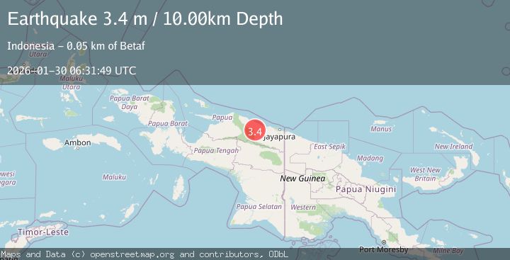
Earthquake Near North Coast of West Papua
Fri, 30 Jan 2026 06:31:48 GMT
Time6 hours ago
Location
-2.2740, 139.2585
Depth
53.8 KM
Event Summary
A 3.4 magnitude earthquake struck on Near North Coast of West Papua, at Fri, 30 Jan 2026 06:31:48 GMT. Depth: 53.787445km. Reviewed by BMKG seismologists, this minor quake occurred at a magnitude type of M.
Magnitude
3.4
M
Source
BMKG
Intensity
-
Agency Reports
1 Sources| Source | Magnitude | Depth | Time |
|---|---|---|---|
| BMKGPrimary | 3.4 | 54 km | 6 hours ago |
Earthquake Details
AutomaticEvent IDbmg2026cbmn
Tsunami PotentialNo
Magnitude TypeM
Nearest Places
- Gunung Worwor5.5 km
- Air Buti9.0 km
- Gunung Temongsir9.4 km
- Raitim12.4 km
- Itik14.0 km
Comments
Join the discussion about this event.
Latest Earthquakes
4.8Mag
Mindanao, Philippines
Time6 hours ago
Depth29.99 km
SourceBMKG (Automatic)
3.1Mag
Java, Indonesia
Time6 hours ago
Depth5.00 km
SourceBMKG (Automatic)
3.9Mag
OFFSHORE O'HIGGINS, CHILE
Time6 hours ago
Depth22.20 km
SourceCSN (Automatic)
1.5Mag
17 km NNE of Ridgecrest, CA
Time6 hours ago
Depth8.41 km
SourceUSGS (Automatic)
2.0Mag
EASTERN TURKEY
Time6 hours ago
Depth7.80 km
SourceKOERI (Automatic)
Nearby Earthquakes
3.2Mag
Near North Coast of West Papua
Time1 week ago
Depth25.99 km
SourceBMKG (Automatic)
2.5Mag
Near North Coast of West Papua
Time4 days ago
Depth30.91 km
SourceBMKG (Automatic)
2.8Mag
PAPUA, INDONESIA
Time1 week ago
Depth47.00 km
SourceBMKG (Automatic)
4.4Mag
West Papua, Indonesia
Time1 week ago
Depth23.70 km
SourceBMKG (Automatic)
2.7Mag
West Papua, Indonesia
Time4 days ago
Depth73.44 km
SourceBMKG (Automatic)