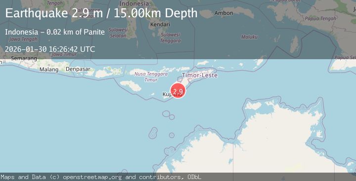
Earthquake Timor Region
Fri, 30 Jan 2026 16:26:42 GMT
Time1 hour ago
Location
-10.1977, 124.1095
Depth
14.6 KM
Event Summary
A 2.9 magnitude earthquake struck on Timor Region, at Fri, 30 Jan 2026 16:26:42 GMT. Depth: 14.585329km. Reviewed by BMKG seismologists, this minor quake occurred at a magnitude type of M.
Magnitude
2.9
M
Source
BMKG
Intensity
-
Agency Reports
1 Sources| Source | Magnitude | Depth | Time |
|---|---|---|---|
| BMKGPrimary | 2.9 | 15 km | 1 hour ago |
Earthquake Details
AutomaticEvent IDbmg2026ccgd
Tsunami PotentialNo
Magnitude TypeM
Nearest Places
- Tanjung Fatumaunaek1.5 km
- Uf Noni2.0 km
- Pulau Menifom2.1 km
- Tanjung Aitea2.4 km
- Noe Bikoen2.5 km
Comments
Join the discussion about this event.
Latest Earthquakes
2.2Mag
52 km ENE of Pedro Bay, Alaska
Time1 hour ago
Depth122.70 km
SourceUSGS (Automatic)
2.9Mag
Java, Indonesia
Time1 hour ago
Depth198.67 km
SourceBMKG (Automatic)
1.8Mag
48 km NW of Tatitlek, Alaska
Time1 hour ago
Depth17.40 km
SourceUSGS (Automatic)
2.5Mag
West Papua Region, Indonesia
Time2 hours ago
Depth10.00 km
SourceBMKG (Automatic)
2.8Mag
DODECANESE IS.-TURKEY BORDER REG
Time2 hours ago
Depth7.70 km
SourceKOERI (Automatic)
Nearby Earthquakes
3.3Mag
Timor Region
Time5 days ago
Depth5.21 km
SourceBMKG (Automatic)
2.5Mag
Timor Region
Time3 hours ago
Depth13.32 km
SourceBMKG (Automatic)
2.2Mag
Timor Region
Time22 hours ago
Depth5.01 km
SourceBMKG (Automatic)
2.8Mag
TIMOR REGION, INDONESIA
Time5 days ago
Depth26.00 km
SourceBMKG (Automatic)
3.9Mag
Timor Region
Time5 days ago
Depth48.21 km
SourceBMKG (Automatic)