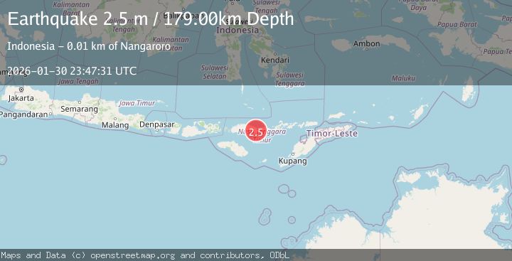
Earthquake Flores Region, Indonesia
Fri, 30 Jan 2026 23:47:28 GMT
Time5 hours ago
Location
-8.5206, 121.4348
Depth
195.6 KM
Event Summary
A 2.3 magnitude earthquake struck on Flores Region, Indonesia, at Fri, 30 Jan 2026 23:47:28 GMT. Depth: 195.55806km. Reviewed by BMKG seismologists, this minor quake occurred at a magnitude type of M.
Magnitude
2.3
M
Source
BMKG
Intensity
-
Agency Reports
1 Sources| Source | Magnitude | Depth | Time |
|---|---|---|---|
| BMKGPrimary | 2.3 | 196 km | 5 hours ago |
Earthquake Details
AutomaticEvent IDbmg2026ccur
Tsunami PotentialNo
Magnitude TypeM
Nearest Places
- Takat Nanganio1.9 km
- Takat Watupuru2.5 km
- Takat Lombo2.6 km
- Takat Sakaso4.1 km
- Takat Pu4.3 km
Comments
Join the discussion about this event.
Latest Earthquakes
1.6Mag
9 km SE of Isla Vista, CA
Time5 hours ago
Depth3.86 km
SourceUSGS (Automatic)
2.3Mag
35 km NW of Toyah, Texas
Time5 hours ago
Depth4.45 km
SourceUSGS (Automatic)
2.6Mag
Java, Indonesia
Time5 hours ago
Depth79.01 km
SourceBMKG (Automatic)
3.2Mag
Northern Molucca Sea
Time5 hours ago
Depth227.49 km
SourceBMKG (Automatic)
1.3Mag
8 km NW of The Geysers, CA
Time5 hours ago
Depth1.64 km
SourceUSGS (Automatic)
Nearby Earthquakes
3.1Mag
Flores Region, Indonesia
Time5 days ago
Depth1.78 km
SourceBMKG (Automatic)
2.4Mag
Flores Region, Indonesia
Time1 week ago
Depth21.00 km
SourceBMKG (Automatic)
2.6Mag
FLORES REGION, INDONESIA
Time2 days ago
Depth19.00 km
SourceBMKG (Automatic)
2.6Mag
Flores Sea
Time3 days ago
Depth21.23 km
SourceBMKG (Automatic)
2.3Mag
Flores Sea
Time2 days ago
Depth11.71 km
SourceBMKG (Automatic)