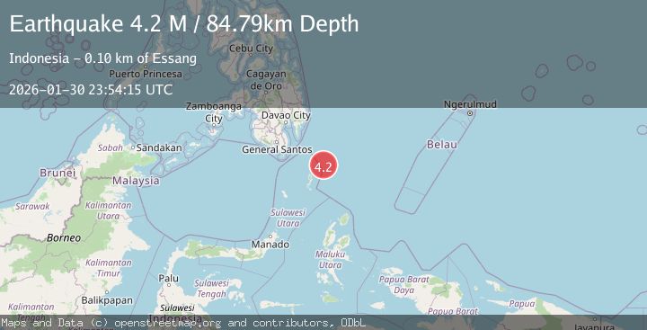
Earthquake Philippine Islands Region
Fri, 30 Jan 2026 23:54:14 GMT
Time5 hours ago
Location
5.0620, 127.4189
Depth
108.7 KM
Event Summary
A 3.7 magnitude earthquake struck on Philippine Islands Region, at Fri, 30 Jan 2026 23:54:14 GMT. Depth: 108.743362km. Reviewed by BMKG seismologists, this minor quake occurred at a magnitude type of M.
Magnitude
3.7
M
Source
BMKG
Intensity
-
Agency Reports
1 Sources| Source | Magnitude | Depth | Time |
|---|---|---|---|
| BMKGPrimary | 3.7 | 109 km | 5 hours ago |
Earthquake Details
AutomaticEvent IDbmg2026ccux
Tsunami PotentialNo
Magnitude TypeM
Nearest Places
- Desa Marampit Timur46.0 km
- Desa Marampit46.5 km
- Kecamatan Nanusa47.1 km
- Pulau Marampit47.2 km
- Desa Dampulis47.3 km
Comments
Join the discussion about this event.
Latest Earthquakes
2.5Mag
Flores Region, Indonesia
Time5 hours ago
Depth178.98 km
SourceBMKG (Automatic)
1.6Mag
9 km SE of Isla Vista, CA
Time5 hours ago
Depth3.86 km
SourceUSGS (Automatic)
2.3Mag
35 km NW of Toyah, Texas
Time5 hours ago
Depth4.45 km
SourceUSGS (Automatic)
2.6Mag
Java, Indonesia
Time5 hours ago
Depth79.01 km
SourceBMKG (Automatic)
3.2Mag
Northern Molucca Sea
Time5 hours ago
Depth227.49 km
SourceBMKG (Automatic)
Nearby Earthquakes
3.4Mag
MINDANAO, PHILIPPINES
Time3 days ago
Depth83.00 km
SourcePIVS (Automatic)
3.3Mag
MINDANAO, PHILIPPINES
Time6 days ago
Depth3.00 km
SourcePIVS (Automatic)
3.8Mag
Mindanao, Philippines
Time6 days ago
Depth43.36 km
SourceBMKG (Automatic)
3.2Mag
PHILIPPINE ISLANDS REGION
Time3 days ago
Depth4.00 km
SourcePIVS (Automatic)
4.5Mag
Mindanao, Philippines
Time1 week ago
Depth14.02 km
SourceBMKG (Automatic)