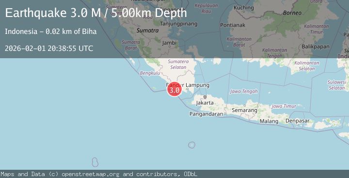
Earthquake Southern Sumatra, Indonesia
Sun, 01 Feb 2026 20:38:55 GMT
Time1 day ago
Location
-5.4583, 104.1008
Depth
5.0 KM
Event Summary
A 3.0 magnitude earthquake struck on Southern Sumatra, Indonesia, at Sun, 01 Feb 2026 20:38:55 GMT. Depth: 5km. Reviewed by BMKG seismologists, this minor quake occurred at a magnitude type of M.
Magnitude
3.0
M
Source
BMKG
Intensity
-
Agency Reports
1 Sources| Source | Magnitude | Depth | Time |
|---|---|---|---|
| BMKGPrimary | 3.0 | 5 km | 1 day ago |
Earthquake Details
AutomaticEvent IDbmg2026cgfm
Tsunami PotentialNo
Magnitude TypeM
Nearest Places
- Wai Tembuli2.1 km
- Desa Muara Tembulih2.6 km
- Wai Telemah3.5 km
- Banjarnegeri3.9 km
- Wai Mondan4.8 km
Comments
Join the discussion about this event.
Latest Earthquakes
3.5Mag
West Papua Region, Indonesia
Time7 hours ago
Depth10.00 km
SourceBMKG (Automatic)
2.3Mag
Sulawesi, Indonesia
Time7 hours ago
Depth6.12 km
SourceBMKG (Automatic)
2.7Mag
TARAPACA, CHILE
Time7 hours ago
Depth116.50 km
SourceCSN (Automatic)
1.8Mag
68 km ESE of Cantwell, Alaska
Time7 hours ago
Depth2.20 km
SourceUSGS (Automatic)
2.5Mag
MINAHASA, SULAWESI, INDONESIA
Time7 hours ago
Depth190.00 km
SourceBMKG (Automatic)
Nearby Earthquakes
2.5Mag
Southern Sumatra, Indonesia
Time6 days ago
Depth10.48 km
SourceBMKG (Automatic)
2.5Mag
Southern Sumatra, Indonesia
Time3 days ago
Depth100.12 km
SourceBMKG (Automatic)
2.7Mag
Southern Sumatra, Indonesia
Time1 week ago
Depth27.97 km
SourceBMKG (Automatic)
2.6Mag
Southern Sumatra, Indonesia
Time4 days ago
Depth18.59 km
SourceBMKG (Automatic)
2.0Mag
Southern Sumatra, Indonesia
Time4 days ago
Depth10.00 km
SourceBMKG (Automatic)