Earthquake Southern Sumatra, Indonesia
Mon, 02 Feb 2026 04:06:42 GMT
Time22 hours ago
Location
-3.5189, 102.1296
Depth
73.1 KM
Event Summary
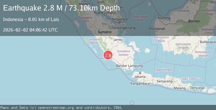
A 2.8 magnitude earthquake struck on Southern Sumatra, Indonesia, at Mon, 02 Feb 2026 04:06:42 GMT. Depth: 73.102287km. Reviewed by BMKG seismologists, this minor quake occurred at a magnitude type of M.
Magnitude
2.8
M
Source
BMKG
Intensity
-
Agency Reports
1 Sources| Source | Magnitude | Depth | Time |
|---|---|---|---|
| BMKGPrimary | 2.8 | 73 km | 22 hours ago |
Earthquake Details
AutomaticEvent IDbmg2026cgug
Tsunami PotentialNo
Magnitude TypeM
Nearest Places
- Desa Talang Pungguk0.2 km
- Palangrena1.4 km
- Kecamatan Air Besi1.4 km
- Desa Sungai Pura2.0 km
- Desa Tanjung Genting2.1 km
Comments
Join the discussion about this event.
Latest Earthquakes
3.6Mag
WESTERN XIZANG
Time22 hours ago
Depth145.40 km
SourceNDI (Automatic)
2.5Mag
NEAR COAST OF NICARAGUA
Time22 hours ago
Depth31.00 km
SourceINET (Automatic)
1.7Mag
3 km E of San Ramon, CA
Time22 hours ago
Depth7.52 km
SourceUSGS (Automatic)
2.3Mag
Northern Sumatra, Indonesia
Time22 hours ago
Depth1.11 km
SourceBMKG (Automatic)
2.0Mag
0 km SE of Guayanilla, Puerto Rico
Time22 hours ago
Depth18.40 km
SourceUSGS
Nearby Earthquakes
3.6Mag
Southern Sumatra, Indonesia
Time5 days ago
Depth72.51 km
SourceBMKG (Automatic)
2.8Mag
Southern Sumatra, Indonesia
Time4 days ago
Depth39.99 km
SourceBMKG (Automatic)
3.2Mag
Southern Sumatra, Indonesia
Time4 days ago
Depth23.74 km
SourceBMKG (Automatic)
2.6Mag
Southern Sumatra, Indonesia
Time1 week ago
Depth25.66 km
SourceBMKG (Automatic)
2.7Mag
Southern Sumatra, Indonesia
Time1 week ago
Depth129.75 km
SourceBMKG (Automatic)