Earthquake Southern Molucca Sea
Mon, 02 Feb 2026 12:19:50 GMT
Time6 hours ago
Location
-0.2088, 124.6888
Depth
15.6 KM
Event Summary
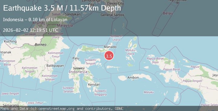
A 3.4 magnitude earthquake struck on Southern Molucca Sea, at Mon, 02 Feb 2026 12:19:50 GMT. Depth: 15.579529km. Reviewed by BMKG seismologists, this minor quake occurred at a magnitude type of M.
Magnitude
3.4
M
Source
BMKG
Intensity
-
Agency Reports
1 Sources| Source | Magnitude | Depth | Time |
|---|---|---|---|
| BMKGPrimary | 3.4 | 16 km | 6 hours ago |
Earthquake Details
AutomaticEvent IDbmg2026chkn
Tsunami PotentialNo
Magnitude TypeM
Nearest Places
- Pulau Lampu76.7 km
- Gorontalo Basin76.7 km
- Tanjung Payunga77.2 km
- Batu Mandi77.6 km
- Libuton Babi77.6 km
Comments
Join the discussion about this event.
Latest Earthquakes
2.6Mag
CENTRAL CALIFORNIA
Time6 hours ago
Depth6.20 km
SourceNC (Automatic)
3.4Mag
ASSAM, INDIA
Time6 hours ago
Depth5.00 km
SourceNDI (Automatic)
3.3Mag
SAN JUAN, ARGENTINA
Time6 hours ago
Depth105.40 km
SourceCSN (Automatic)
2.9Mag
Northern Molucca Sea
Time6 hours ago
Depth24.83 km
SourceBMKG (Automatic)
2.5Mag
FRANCE
Time6 hours ago
Depth5.00 km
SourceReNaSS (Automatic)
Nearby Earthquakes
4.3Mag
Southern Molucca Sea
Time1 week ago
Depth5.64 km
SourceBMKG (Automatic)
3.0Mag
MOLUCCA SEA
Time1 week ago
Depth9.00 km
SourceBMKG (Automatic)
3.0Mag
Southern Molucca Sea
Time2 days ago
Depth12.21 km
SourceBMKG (Automatic)
5.1Mag
Southern Molucca Sea
Time3 days ago
Depth10.00 km
SourceBMKG (Automatic)
4.3Mag
Southern Molucca Sea
Time1 week ago
Depth11.97 km
SourceBMKG (Automatic)