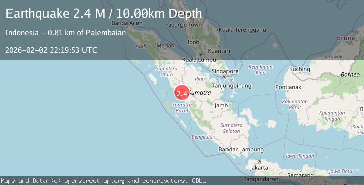
Earthquake Southern Sumatra, Indonesia
Mon, 02 Feb 2026 22:19:53 GMT
Time1 hour ago
Location
-0.1596, 100.1175
Depth
10.0 KM
Event Summary
A 2.2 magnitude earthquake struck on Southern Sumatra, Indonesia, at Mon, 02 Feb 2026 22:19:53 GMT. Depth: 10km. Reviewed by BMKG seismologists, this minor quake occurred at a magnitude type of M.
Magnitude
2.2
M
Source
BMKG
Intensity
-
Agency Reports
1 Sources| Source | Magnitude | Depth | Time |
|---|---|---|---|
| BMKGPrimary | 2.2 | 10 km | 1 hour ago |
Earthquake Details
AutomaticEvent IDbmg2026cieh
Tsunami PotentialNo
Magnitude TypeM
Nearest Places
- Kotoalam0.9 km
- Kepalobandar3.2 km
- Alahananggang3.6 km
- Simpangtigo3.9 km
- Nagari Sitalang3.9 km
Comments
Join the discussion about this event.
Latest Earthquakes
2.5Mag
Sumbawa Region, Indonesia
Time1 hour ago
Depth77.93 km
SourceBMKG (Automatic)
1.1Mag
61 km S of Whites City, New Mexico
Time2 hours ago
Depth2.94 km
SourceUSGS (Automatic)
2.5Mag
Java, Indonesia
Time2 hours ago
Depth25.51 km
SourceBMKG (Automatic)
4.8Mag
OFF EAST COAST OF HONSHU, JAPAN
Time2 hours ago
Depth30.00 km
SourceJMA (Automatic)
1.8Mag
10 km ESE of Pearsall, Texas
Time2 hours ago
Depth8.90 km
SourceUSGS (Automatic)
Nearby Earthquakes
2.1Mag
Southern Sumatra, Indonesia
Time3 days ago
Depth17.85 km
SourceBMKG (Automatic)
2.7Mag
Northern Sumatra, Indonesia
Time4 days ago
Depth14.71 km
SourceBMKG (Automatic)
2.5Mag
NORTHERN SUMATRA, INDONESIA
Time1 week ago
Depth8.00 km
SourceBMKG (Automatic)
3.5Mag
Southern Sumatra, Indonesia
Time1 day ago
Depth2.71 km
SourceBMKG (Automatic)
2.9Mag
Northern Sumatra, Indonesia
Time1 week ago
Depth139.67 km
SourceBMKG (Automatic)