Earthquake Minahassa Peninsula, Sulawesi
Wed, 04 Feb 2026 20:42:13 GMT
Time2 hours ago
Location
0.9878, 120.0475
Depth
3.5 KM
Event Summary
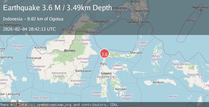
A 3.6 magnitude earthquake struck on Minahassa Peninsula, Sulawesi, at Wed, 04 Feb 2026 20:42:13 GMT. Depth: 3.494632km. Reviewed by BMKG seismologists, this minor quake occurred at a magnitude type of M.
Magnitude
3.6
M
Source
BMKG
Intensity
-
Agency Reports
1 Sources| Source | Magnitude | Depth | Time |
|---|---|---|---|
| BMKGPrimary | 3.6 | 3 km | 2 hours ago |
Earthquake Details
AutomaticEvent IDbmg2026clsc
Tsunami PotentialNo
Magnitude TypeM
Nearest Places
- Pasie Seranga19.3 km
- Pasie Stokan19.6 km
- Pulau Lingayan21.4 km
- Lingayan21.6 km
- Teluk Dampal21.7 km
Comments
Join the discussion about this event.
Latest Earthquakes
2.3Mag
West Papua Region, Indonesia
Time2 hours ago
Depth10.00 km
SourceBMKG (Automatic)
2.4Mag
Minahassa Peninsula, Sulawesi
Time2 hours ago
Depth86.87 km
SourceBMKG (Automatic)
2.2Mag
ALBANIA
Time3 hours ago
Depth15.00 km
SourceIGEO (Automatic)
2.4Mag
Northern Sumatra, Indonesia
Time3 hours ago
Depth64.64 km
SourceBMKG (Automatic)
3.0Mag
PHILIPPINE ISLANDS REGION
Time3 hours ago
Depth32.00 km
SourcePIVS (Automatic)
Nearby Earthquakes
2.5Mag
Minahassa Peninsula, Sulawesi
Time6 days ago
Depth40.29 km
SourceBMKG (Automatic)
2.7Mag
Minahassa Peninsula, Sulawesi
Time1 day ago
Depth17.38 km
SourceBMKG (Automatic)
3.5Mag
Minahassa Peninsula, Sulawesi
Time4 days ago
Depth4.12 km
SourceBMKG (Automatic)
2.3Mag
Minahassa Peninsula, Sulawesi
Time3 days ago
Depth48.44 km
SourceBMKG (Automatic)
2.6Mag
Minahassa Peninsula, Sulawesi
Time1 week ago
Depth52.69 km
SourceBMKG (Automatic)