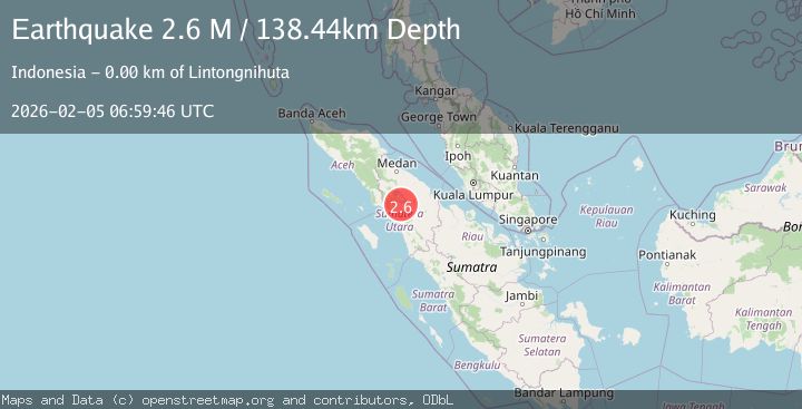
Earthquake Northern Sumatra, Indonesia
Thu, 05 Feb 2026 06:59:46 GMT
Time3 hours ago
Location
2.4916, 98.9161
Depth
142.1 KM
Event Summary
A 2.2 magnitude earthquake struck on Northern Sumatra, Indonesia, at Thu, 05 Feb 2026 06:59:46 GMT. Depth: 142.099121km. Reviewed by BMKG seismologists, this minor quake occurred at a magnitude type of M.
Magnitude
2.2
M
Source
BMKG
Intensity
-
Agency Reports
1 Sources| Source | Magnitude | Depth | Time |
|---|---|---|---|
| BMKGPrimary | 2.2 | 142 km | 3 hours ago |
Earthquake Details
AutomaticEvent IDbmg2026cmml
Tsunami PotentialNo
Magnitude TypeM
Nearest Places
- Sosorbaiyun0.4 km
- Huta Julu0.5 km
- Pambaiyunan0.5 km
- Buntunauli0.7 km
- Desa Toguan Galung0.8 km
Comments
Join the discussion about this event.
Latest Earthquakes
0.7Mag
3 km NW of Loma Linda, CA
Time3 hours ago
Depth3.98 km
SourceUSGS (Automatic)
3.0Mag
West Papua Region, Indonesia
Time3 hours ago
Depth12.90 km
SourceBMKG (Automatic)
2.1Mag
Sulawesi, Indonesia
Time3 hours ago
Depth5.00 km
SourceBMKG (Automatic)
2.3Mag
Northern Sumatra, Indonesia
Time3 hours ago
Depth4.90 km
SourceBMKG (Automatic)
2.6Mag
WESTERN TEXAS
Time3 hours ago
Depth1.60 km
SourceTX (Automatic)
Nearby Earthquakes
2.3Mag
Northern Sumatra, Indonesia
Time2 days ago
Depth137.51 km
SourceBMKG (Automatic)
3.2Mag
Northern Sumatra, Indonesia
Time3 days ago
Depth128.79 km
SourceBMKG (Automatic)
2.2Mag
Northern Sumatra, Indonesia
Time6 days ago
Depth11.65 km
SourceBMKG (Automatic)
2.7Mag
Northern Sumatra, Indonesia
Time2 weeks ago
Depth8.59 km
SourceBMKG (Automatic)
2.5Mag
Northern Sumatra, Indonesia
Time2 weeks ago
Depth4.40 km
SourceBMKG (Automatic)