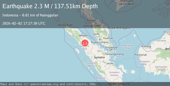
Earthquake Northern Sumatra, Indonesia
Mon, 02 Feb 2026 17:27:31 GMT
Time4 hours ago
Location
2.2770, 98.8460
Depth
125.1 KM
Event Summary
A 2.1 magnitude earthquake struck on Northern Sumatra, Indonesia, at Mon, 02 Feb 2026 17:27:31 GMT. Depth: 125.135239km. Reviewed by BMKG seismologists, this minor quake occurred at a magnitude type of M.
Magnitude
2.1
M
Source
BMKG
Intensity
-
Agency Reports
1 Sources| Source | Magnitude | Depth | Time |
|---|---|---|---|
| BMKGPrimary | 2.1 | 125 km | 4 hours ago |
Earthquake Details
AutomaticEvent IDbmg2026chur
Tsunami PotentialNo
Magnitude TypeM
Nearest Places
- Huta Bongbong0.2 km
- Huta Tua1.0 km
- Huta Tua1.0 km
- Desa Sitolu Bahal1.1 km
- Siguriguri Dolok1.1 km
Comments
Join the discussion about this event.
Latest Earthquakes
2.8Mag
Off West Coast of Northern Sumatra
Time4 hours ago
Depth56.43 km
SourceBMKG (Automatic)
1.7Mag
55 km NW of Toyah, Texas
Time4 hours ago
Depth4.04 km
SourceUSGS (Automatic)
2.9Mag
Northern Sumatra, Indonesia
Time4 hours ago
Depth14.46 km
SourceBMKG (Automatic)
3.0Mag
Sumbawa Region, Indonesia
Time4 hours ago
Depth10.00 km
SourceBMKG (Automatic)
3.2Mag
WESTERN TURKEY
Time4 hours ago
Depth12.80 km
SourceAFAD (Automatic)
Nearby Earthquakes
3.2Mag
Northern Sumatra, Indonesia
Time12 hours ago
Depth128.79 km
SourceBMKG (Automatic)
2.7Mag
Northern Sumatra, Indonesia
Time1 week ago
Depth8.59 km
SourceBMKG (Automatic)
2.5Mag
Northern Sumatra, Indonesia
Time1 week ago
Depth4.40 km
SourceBMKG (Automatic)
2.2Mag
Northern Sumatra, Indonesia
Time4 days ago
Depth11.65 km
SourceBMKG (Automatic)
2.1Mag
Northern Sumatra, Indonesia
Time3 days ago
Depth3.24 km
SourceBMKG (Automatic)