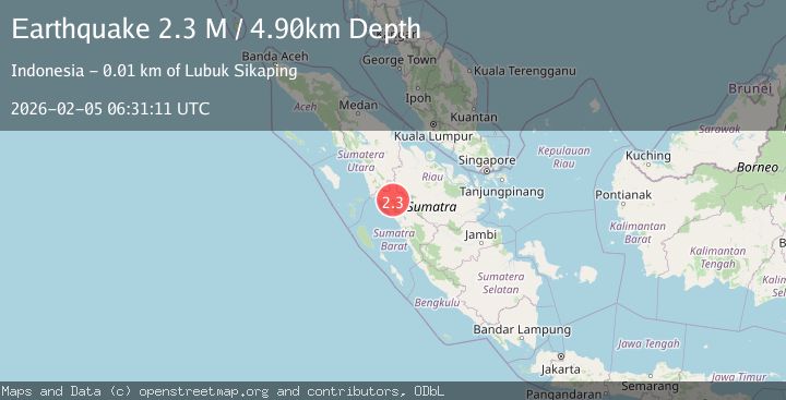
Earthquake Northern Sumatra, Indonesia
Thu, 05 Feb 2026 06:31:11 GMT
Time5 hours ago
Location
0.1435, 100.0847
Depth
4.3 KM
Event Summary
A 2.2 magnitude earthquake struck on Northern Sumatra, Indonesia, at Thu, 05 Feb 2026 06:31:11 GMT. Depth: 4.259849km. Reviewed by BMKG seismologists, this minor quake occurred at a magnitude type of M.
Magnitude
2.2
M
Source
BMKG
Intensity
-
Agency Reports
1 Sources| Source | Magnitude | Depth | Time |
|---|---|---|---|
| BMKGPrimary | 2.2 | 4 km | 5 hours ago |
Earthquake Details
AutomaticEvent IDbmg2026cmln
Tsunami PotentialNo
Magnitude TypeM
Nearest Places
- Nagari Jambak3.9 km
- Kecamatan Lubuk Sikaping4.0 km
- Bukit Tanah Runtuh5.1 km
- Nagari Aia Manggih6.4 km
- Padang6.8 km
Comments
Join the discussion about this event.
Latest Earthquakes
2.6Mag
WESTERN TEXAS
Time5 hours ago
Depth1.60 km
SourceTX (Automatic)
2.3Mag
CROATIA
Time5 hours ago
Depth1.20 km
SourceARSO (Automatic)
2.8Mag
Sumbawa Region, Indonesia
Time5 hours ago
Depth14.64 km
SourceBMKG (Automatic)
2.1Mag
NORTHERN ITALY
Time5 hours ago
Depth25.20 km
SourceINGV (Automatic)
2.3Mag
SAN FRANCISCO BAY AREA, CALIF.
Time5 hours ago
Depth3.10 km
SourceNC (Automatic)
Nearby Earthquakes
2.4Mag
Northern Sumatra, Indonesia
Time1 day ago
Depth9.60 km
SourceBMKG (Automatic)
2.5Mag
NORTHERN SUMATRA, INDONESIA
Time1 week ago
Depth8.00 km
SourceBMKG (Automatic)
2.7Mag
Northern Sumatra, Indonesia
Time1 week ago
Depth14.71 km
SourceBMKG (Automatic)
2.1Mag
Southern Sumatra, Indonesia
Time6 days ago
Depth17.85 km
SourceBMKG (Automatic)
2.4Mag
Southern Sumatra, Indonesia
Time2 days ago
Depth10.00 km
SourceBMKG (Automatic)