Earthquake South of Sumbawa, Indonesia
Thu, 05 Feb 2026 07:11:41 GMT
Time1 hour ago
Location
-10.3743, 118.8203
Depth
10.0 KM
Event Summary
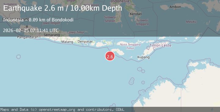
A 2.6 magnitude earthquake struck on South of Sumbawa, Indonesia, at Thu, 05 Feb 2026 07:11:41 GMT. Depth: 10km. Reviewed by BMKG seismologists, this minor quake occurred at a magnitude type of M.
Magnitude
2.6
M
Source
BMKG
Intensity
-
Agency Reports
1 Sources| Source | Magnitude | Depth | Time |
|---|---|---|---|
| BMKGPrimary | 2.6 | 10 km | 1 hour ago |
Earthquake Details
AutomaticEvent IDbmg2026cmmw
Tsunami PotentialNo
Magnitude TypeM
Nearest Places
- Tanjung Mareha79.0 km
- Tanjung Rica79.1 km
- Tanjung Matogola79.3 km
- Pulau Baholokmonegoro79.3 km
- Pulau Barenggemonokodi79.3 km
Comments
Join the discussion about this event.
Latest Earthquakes
1.5Mag
33 km E of Balmorhea, Texas
Time1 hour ago
Depth5.46 km
SourceUSGS (Automatic)
0.8Mag
8 km W of Cobb, CA
Time1 hour ago
Depth1.89 km
SourceUSGS (Automatic)
1.4Mag
13 km N of Borrego Springs, CA
Time1 hour ago
Depth10.87 km
SourceUSGS (Automatic)
2.2Mag
Near North Coast of West Papua
Time1 hour ago
Depth10.00 km
SourceBMKG (Automatic)
2.6Mag
Northern Sumatra, Indonesia
Time1 hour ago
Depth138.44 km
SourceBMKG (Automatic)
Nearby Earthquakes
3.2Mag
Sumba Region, Indonesia
Time2 weeks ago
Depth6.75 km
SourceBMKG (Automatic)
3.9Mag
Sumba Region, Indonesia
Time6 days ago
Depth10.00 km
SourceBMKG (Automatic)
2.9Mag
South of Sumbawa, Indonesia
Time4 days ago
Depth123.25 km
SourceBMKG (Automatic)
3.9Mag
Sumba Region, Indonesia
Time5 days ago
Depth3.63 km
SourceBMKG (Automatic)
2.7Mag
South of Sumbawa, Indonesia
Time1 week ago
Depth10.00 km
SourceBMKG (Automatic)