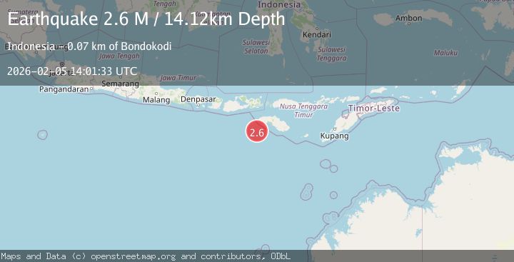
Earthquake South of Sumbawa, Indonesia
Thu, 05 Feb 2026 14:01:33 GMT
Time1 hour ago
Location
-10.2291, 118.8356
Depth
14.1 KM
Event Summary
A 2.6 magnitude earthquake struck on South of Sumbawa, Indonesia, at Thu, 05 Feb 2026 14:01:33 GMT. Depth: 14.122783km. Reviewed by BMKG seismologists, this minor quake occurred at a magnitude type of M.
Magnitude
2.6
M
Source
BMKG
Intensity
-
Agency Reports
1 Sources| Source | Magnitude | Depth | Time |
|---|---|---|---|
| BMKGPrimary | 2.6 | 14 km | 1 hour ago |
Earthquake Details
AutomaticEvent IDbmg2026cnaj
Tsunami PotentialNo
Magnitude TypeM
Nearest Places
- Tanjung Mareha63.6 km
- Tanjung Waikataku63.8 km
- Pulau Malondobara63.9 km
- Pulau Baholokmonegoro64.0 km
- Pulau Barenggemonokodi64.0 km
Comments
Join the discussion about this event.
Latest Earthquakes
3.0Mag
Talaud Islands, Indonesia
Time10 minutes ago
Depth16.97 km
SourceBMKG (Automatic)
2.6Mag
STRAIT OF GIBRALTAR
Time13 minutes ago
Depth30.00 km
SourceIGN (Automatic)
2.3Mag
Sulawesi, Indonesia
Time14 minutes ago
Depth2.34 km
SourceBMKG (Automatic)
2.9Mag
Sumbawa Region, Indonesia
Time14 minutes ago
Depth15.62 km
SourceBMKG (Automatic)
2.7Mag
BANDA SEA
Time17 minutes ago
Depth92.00 km
SourceBMKG (Automatic)
Nearby Earthquakes
2.6Mag
South of Sumbawa, Indonesia
Time8 hours ago
Depth10.00 km
SourceBMKG (Automatic)
2.9Mag
South of Sumbawa, Indonesia
Time4 days ago
Depth123.25 km
SourceBMKG (Automatic)
3.2Mag
Sumba Region, Indonesia
Time2 weeks ago
Depth6.75 km
SourceBMKG (Automatic)
3.9Mag
Sumba Region, Indonesia
Time6 days ago
Depth10.00 km
SourceBMKG (Automatic)
3.9Mag
Sumba Region, Indonesia
Time5 days ago
Depth3.63 km
SourceBMKG (Automatic)