Earthquake Southern Molucca Sea
Thu, 05 Feb 2026 15:46:57 GMT
Time3 hours ago
Location
-0.4290, 124.5735
Depth
8.8 KM
Event Summary
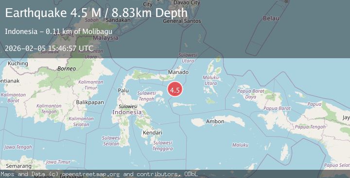
A 4.5 magnitude earthquake struck on Southern Molucca Sea, at Thu, 05 Feb 2026 15:46:57 GMT. Depth: 8.834548km. Reviewed by BMKG seismologists, this light quake occurred at a magnitude type of M.
Magnitude
4.5
M
Source
BMKG
Intensity
-
Agency Reports
1 Sources| Source | Magnitude | Depth | Time |
|---|---|---|---|
| BMKGPrimary | 4.5 | 9 km | 3 hours ago |
Earthquake Details
AutomaticEvent IDbmg2026cndv
Tsunami PotentialNo
Magnitude TypeM
Nearest Places
- Gorontalo Basin66.8 km
- Pulau Molosso86.6 km
- Libuton Pondanmointok97.4 km
- Pulau-pulau Batutolu97.6 km
- Impoda Bulu97.7 km
Comments
Join the discussion about this event.
Latest Earthquakes
3.0Mag
Flores Region, Indonesia
Time2 hours ago
Depth204.39 km
SourceBMKG (Automatic)
2.0Mag
Bali Sea
Time2 hours ago
Depth10.00 km
SourceBMKG (Automatic)
5.2Mag
FIJI REGION
Time2 hours ago
Depth581.00 km
SourceEMSC (Automatic)
2.3Mag
STRAIT OF GIBRALTAR
Time2 hours ago
Depth30.00 km
SourceIGN (Automatic)
0.8Mag
7 km NW of The Geysers, CA
Time3 hours ago
Depth2.62 km
SourceUSGS (Automatic)
Nearby Earthquakes
5.1Mag
Southern Molucca Sea
Time6 days ago
Depth10.00 km
SourceBMKG (Automatic)
4.3Mag
Southern Molucca Sea
Time2 weeks ago
Depth5.64 km
SourceBMKG (Automatic)
4.3Mag
Southern Molucca Sea
Time1 week ago
Depth11.97 km
SourceBMKG (Automatic)
3.0Mag
MOLUCCA SEA
Time1 week ago
Depth9.00 km
SourceBMKG (Automatic)
3.0Mag
Southern Molucca Sea
Time5 days ago
Depth12.21 km
SourceBMKG (Automatic)