Earthquake Timor Region
Fri, 06 Feb 2026 15:46:34 GMT
Time1 hour ago
Location
-10.5929, 124.3729
Depth
27.7 KM
Event Summary
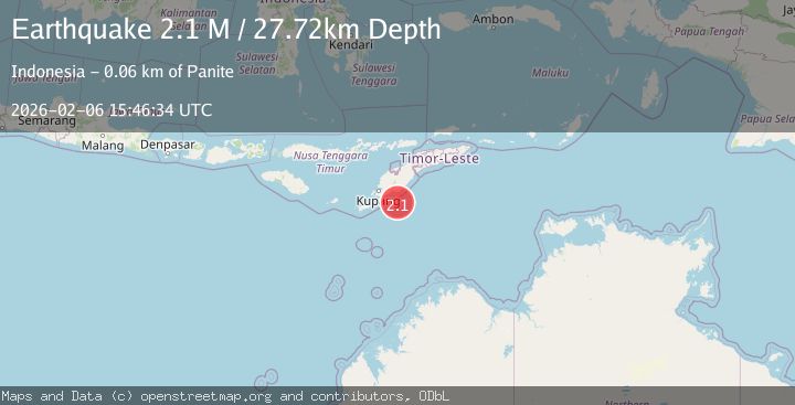
A 2.1 magnitude earthquake struck on Timor Region, at Fri, 06 Feb 2026 15:46:34 GMT. Depth: 27.718643km. Reviewed by BMKG seismologists, this minor quake occurred at a magnitude type of M.
Magnitude
2.1
M
Source
BMKG
Intensity
-
Agency Reports
1 Sources| Source | Magnitude | Depth | Time |
|---|---|---|---|
| BMKGPrimary | 2.1 | 28 km | 1 hour ago |
Earthquake Details
AutomaticEvent IDbmg2026cozi
Tsunami PotentialNo
Magnitude TypeM
Nearest Places
- Tanjung Ela47.5 km
- Oesuenu47.8 km
- Desa Tuafanu49.2 km
- Nifu Kubai49.9 km
- Teluk Noilmina50.0 km
Comments
Join the discussion about this event.
Latest Earthquakes
1.4Mag
3 km N of Dublin, CA
Time5 minutes ago
Depth8.73 km
SourceUSGS (Automatic)
4.1Mag
NEAR EAST COAST OF HONSHU, JAPAN
Time12 minutes ago
Depth10.00 km
SourceJMA (Automatic)
2.7Mag
Java, Indonesia
Time13 minutes ago
Depth28.82 km
SourceBMKG (Automatic)
3.1Mag
KENAI PENINSULA, ALASKA
Time14 minutes ago
Depth71.10 km
SourceAK (Automatic)
2.5Mag
43 km NNE of Ouzinkie, Alaska
Time27 minutes ago
Depth3.80 km
SourceUSGS (Automatic)
Nearby Earthquakes
2.8Mag
Timor Region
Time4 days ago
Depth28.52 km
SourceBMKG (Automatic)
2.9Mag
Timor Region
Time1 day ago
Depth0.00 km
SourceBMKG (Automatic)
2.2Mag
Timor Region
Time1 week ago
Depth5.01 km
SourceBMKG (Automatic)
2.9Mag
Timor Region
Time1 week ago
Depth14.59 km
SourceBMKG (Automatic)
3.9Mag
Timor Region
Time1 week ago
Depth48.21 km
SourceBMKG (Automatic)