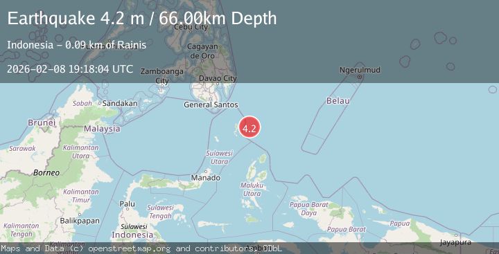
Earthquake Talaud Islands, Indonesia
Sun, 08 Feb 2026 19:18:04 GMT
Time1 hour ago
Location
4.3169, 127.6485
Depth
65.7 KM
Event Summary
A 4.1 magnitude earthquake struck on Talaud Islands, Indonesia, at Sun, 08 Feb 2026 19:18:04 GMT. Depth: 65.671745km. Reviewed by BMKG seismologists, this light quake occurred at a magnitude type of M.
Magnitude
4.1
M
Source
BMKG
Intensity
-
Agency Reports
1 Sources| Source | Magnitude | Depth | Time |
|---|---|---|---|
| BMKGPrimary | 4.1 | 66 km | 1 hour ago |
Earthquake Details
AutomaticEvent IDbmg2026csxi
Tsunami PotentialNo
Magnitude TypeM
Nearest Places
- Talaud Trough43.6 km
- Snellius Ridge52.5 km
- Pulau Kakorotan64.2 km
- Desa Kakorotan64.2 km
- Pulau Intata65.3 km
Comments
Join the discussion about this event.
Latest Earthquakes
2.6Mag
Flores Sea
Time1 hour ago
Depth20.23 km
SourceBMKG (Automatic)
3.6Mag
8 km WNW of Cobb, CA
Time1 hour ago
Depth1.54 km
SourceUSGS (Automatic)
1.3Mag
102 km ESE of McCarthy, Alaska
Time1 hour ago
Depth77.10 km
SourceUSGS (Automatic)
1.6Mag
11 km SE of Pinnacles, CA
Time1 hour ago
Depth6.42 km
SourceUSGS (Automatic)
2.2Mag
Java, Indonesia
Time1 hour ago
Depth5.00 km
SourceBMKG (Automatic)
Nearby Earthquakes
3.7Mag
North of Halmahera, Indonesia
Time1 day ago
Depth96.03 km
SourceBMKG (Automatic)
4.2Mag
Talaud Islands, Indonesia
Time1 week ago
Depth84.79 km
SourceBMKG (Automatic)
4.1Mag
Talaud Islands, Indonesia
Time12 hours ago
Depth87.05 km
SourceBMKG (Automatic)
3.5Mag
Talaud Islands, Indonesia
Time2 weeks ago
Depth18.12 km
SourceBMKG (Automatic)
3.7Mag
Talaud Islands, Indonesia
Time1 week ago
Depth129.80 km
SourceBMKG (Automatic)