Earthquake Northern Molucca Sea
Tue, 10 Feb 2026 14:49:41 GMT
Time1 week ago
Location
2.9769, 127.5451
Depth
10.2 KM
Event Summary
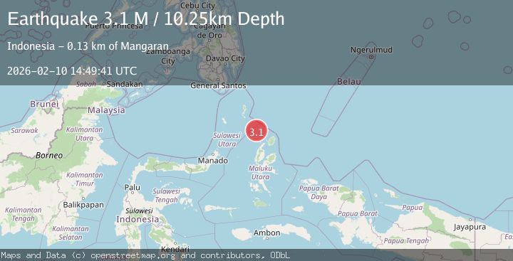
A 3.1 magnitude earthquake struck on Northern Molucca Sea, at Tue, 10 Feb 2026 14:49:41 GMT. Depth: 10.247798km. Reviewed by BMKG seismologists, this minor quake occurred at a magnitude type of M.
Magnitude
3.1
M
Source
BMKG
Intensity
-
Agency Reports
1 Sources| Source | Magnitude | Depth | Time |
|---|---|---|---|
| BMKGPrimary | 3.1 | 10 km | 1 week ago |
Earthquake Details
ManualEvent IDbmg2026cwfm
Tsunami PotentialNo
Magnitude TypeM
Nearest Places
- Pulau Karis36.3 km
- Morotai Basin50.6 km
- Pulau Sedeng79.6 km
- Pulau Deherete81.2 km
- Pulau Takurumagula82.2 km
Comments
Join the discussion about this event.
Latest Earthquakes
2.6Mag
Java, Indonesia
Time11 minutes ago
Depth214.22 km
SourceBMKG
1.0Mag
Southeastern Alaska
Time12 minutes ago
Depth0.00 km
SourceVYT (Automatic)
3.5Mag
COOK STRAIT, NEW ZEALAND
Time13 minutes ago
Depth75.30 km
SourceGNS (Automatic)
2.5Mag
Seram, Indonesia
Time15 minutes ago
Depth21.28 km
SourceBMKG
2.6Mag
West Papua Region, Indonesia
Time17 minutes ago
Depth17.35 km
SourceBMKG
Nearby Earthquakes
3.2Mag
KEPULAUAN TALAUD, INDONESIA
Time1 month ago
Depth70.00 km
SourceBMKG (Automatic)
3.2Mag
Talaud Islands, Indonesia
Time1 week ago
Depth4.00 km
SourceBMKG (Automatic)
2.8Mag
MOLUCCA SEA
Time1 month ago
Depth10.00 km
SourceBMKG (Automatic)
4.0Mag
KEPULAUAN TALAUD, INDONESIA
Time3 years ago
Depth32.00 km
SourceDJA (Automatic)
5.1Mag
MOLUCCA SEA
Time18 years ago
Depth67.00 km
SourceEMSC (Automatic)