Earthquake Near North Coast of West Papua
Wed, 11 Feb 2026 09:37:14 GMT
Time1 week ago
Location
-2.2703, 140.0950
Depth
10.0 KM
Event Summary
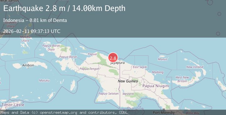
A 2.8 magnitude earthquake struck on Near North Coast of West Papua, at Wed, 11 Feb 2026 09:37:14 GMT. Depth: 10km. Reviewed by BMKG seismologists, this minor quake occurred at a magnitude type of M.
Magnitude
2.8
M
Source
BMKG
Intensity
-
Agency Reports
1 Sources| Source | Magnitude | Depth | Time |
|---|---|---|---|
| BMKGPrimary | 2.8 | 14 km | 1 week ago |
Earthquake Details
ManualEvent IDbmg2026cxqr
Tsunami PotentialNo
Magnitude TypeM
Nearest Places
- Tarfia3.3 km
- Tanjung Kamadara6.0 km
- Teluk Matterer7.8 km
- Tanjung Korongwan7.9 km
- Wai Humbei8.9 km
Comments
Join the discussion about this event.
Latest Earthquakes
1.1Mag
Washington
Time14 hours ago
Depth9.64 km
SourceVYT (Automatic)
1.9Mag
32 km NW of Toyah, Texas
Time14 hours ago
Depth4.09 km
SourceUSGS (Automatic)
1.7Mag
western Texas
Time14 hours ago
Depth3.42 km
SourceVYT (Automatic)
3.8Mag
Seram, Indonesia
Time14 hours ago
Depth0.00 km
SourceVYT (Automatic)
1.6Mag
54 km WNW of Toyah, Texas
Time14 hours ago
Depth0.00 km
SourceUSGS (Automatic)
Nearby Earthquakes
3.3Mag
Near North Coast of West Papua
Time1 week ago
Depth10.00 km
SourceBMKG (Automatic)
2.5Mag
NEAR N COAST OF PAPUA, INDONESIA
Time1 month ago
Depth10.00 km
SourceBMKG (Automatic)
3.0Mag
Near North Coast of West Papua
Time5 days ago
Depth10.00 km
SourceBMKG
2.5Mag
Near North Coast of West Papua
Time6 days ago
Depth10.00 km
SourceBMKG
3.2Mag
Near North Coast of West Papua
Time2 weeks ago
Depth10.00 km
SourceBMKG (Automatic)