Earthquake Sumbawa Region, Indonesia
Sat, 14 Feb 2026 07:21:46 GMT
Time4 days ago
Location
-8.2253, 117.7163
Depth
27.6 KM
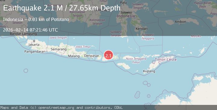
Event Summary
A 2.1 magnitude earthquake struck on Sumbawa Region, Indonesia, at Sat, 14 Feb 2026 07:21:46 GMT. Depth: 27.649635km. Reviewed by BMKG seismologists, this minor quake occurred at a magnitude type of M.
Magnitude
2.1
M
Source
BMKG
Intensity
-
Agency Reports
1 Sources| Source | Magnitude | Depth | Time |
|---|---|---|---|
| BMKGPrimary | 2.1 | 28 km | 4 days ago |
Earthquake Details
ManualEvent IDbmg2026dcys
Tsunami PotentialNo
Magnitude TypeM
Nearest Places
- Doro Mbolo1.3 km
- Teluk Calabai1.4 km
- Latonda Satu1.4 km
- Kampungbaru1.5 km
- Asramapiner1.5 km
Comments
Join the discussion about this event.
Latest Earthquakes
1.4Mag
Kenai Peninsula, Alaska
Time16 hours ago
Depth35.28 km
SourceVYT (Automatic)
1.1Mag
87 km N of Karluk, Alaska
Time16 hours ago
Depth5.00 km
SourceUSGS (Automatic)
2.3Mag
Southern Sumatra, Indonesia
Time16 hours ago
Depth36.72 km
SourceBMKG
2.6Mag
Java, Indonesia
Time16 hours ago
Depth62.13 km
SourceBMKG
1.8Mag
Tarapaca, Chile
Time16 hours ago
Depth0.00 km
SourceVYT (Automatic)
Nearby Earthquakes
2.5Mag
Sumbawa Region, Indonesia
Time3 weeks ago
Depth23.91 km
SourceBMKG (Automatic)
2.7Mag
SUMBAWA REGION, INDONESIA
Time1 month ago
Depth18.00 km
SourceBMKG (Automatic)
2.2Mag
Sumbawa Region, Indonesia
Time3 days ago
Depth10.00 km
SourceBMKG
2.5Mag
Sumbawa Region, Indonesia
Time2 weeks ago
Depth25.00 km
SourceBMKG (Automatic)
2.5Mag
SUMBAWA REGION, INDONESIA
Time1 month ago
Depth11.00 km
SourceBMKG (Automatic)